Home > North America > Canada > Maps
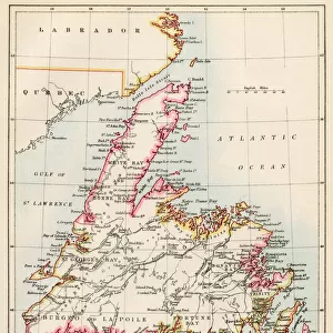
1818, Pinkerton Map of British North America or Canada, John Pinkerton, 1758 - 1826

![]()
Wall Art and Photo Gifts from Liszt Collection
1818, Pinkerton Map of British North America or Canada, John Pinkerton, 1758 - 1826
1818, Pinkerton Map of British North America or Canada, John Pinkerton, 1758 - 1826, Scottish antiquarian, cartographer, UK
Liszt Collection of nineteenth-century engravings and images to browse and enjoy
Media ID 14007015
© Artokoloro Quint Lox Limited
1758 1826 1758 – 1826 17581826 1818 Cartographer John Pinkerton Scottish Antiquarian Antique Map Atlas Chart Geographic Latitude Longitude Mappa Mundi Old Antique Plan Old Antique View Old Map Ols Antique Map Rare Old Maps Topo
FEATURES IN THESE COLLECTIONS
> Europe
> United Kingdom
> Maps
> Maps and Charts
> Early Maps
> Maps and Charts
> World
> North America
> Canada
> Maps
EDITORS COMMENTS
This print showcases the remarkable "1818, Pinkerton Map of British North America or Canada" created by the renowned Scottish antiquarian and cartographer, John Pinkerton. Crafted with meticulous detail and precision, this vintage map offers a fascinating glimpse into the topography, geography, and history of this vast region. With its intricate illustrations and geographic markings, this ancient map serves as both a navigational tool and a work of art. The carefully plotted grid lines denote latitude and longitude coordinates, allowing travelers to chart their course through uncharted territories. Its decorative elements evoke a sense of nostalgia for an era when exploration and discovery were at their peak. The aged paper adds an authentic touch to this historical piece, reminding us of the countless journeys undertaken by early explorers who ventured into these unknown lands. As we gaze upon this rare old map from 1818, we are transported back in time to an age where cartography played a vital role in understanding our world. Whether you're an avid collector or simply intrigued by history's rich tapestry, this antique map is sure to captivate your imagination. It serves as a testament to John Pinkerton's incredible talent as well as his dedication to documenting the ever-changing landscape of British North America or Canada during that period.
MADE IN THE USA
Safe Shipping with 30 Day Money Back Guarantee
FREE PERSONALISATION*
We are proud to offer a range of customisation features including Personalised Captions, Color Filters and Picture Zoom Tools
SECURE PAYMENTS
We happily accept a wide range of payment options so you can pay for the things you need in the way that is most convenient for you
* Options may vary by product and licensing agreement. Zoomed Pictures can be adjusted in the Cart.