Home > Europe > Netherlands > Maps
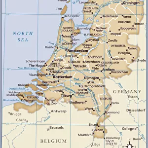
1818, Pinkerton Map of Holland or the Netherlands, John Pinkerton, 1758 - 1826, Scottish

![]()
Wall Art and Photo Gifts from Liszt Collection
1818, Pinkerton Map of Holland or the Netherlands, John Pinkerton, 1758 - 1826, Scottish
1818, Pinkerton Map of Holland or the Netherlands, John Pinkerton, 1758 - 1826, Scottish antiquarian, cartographer, UK
Liszt Collection of nineteenth-century engravings and images to browse and enjoy
Media ID 14007025
© Artokoloro Quint Lox Limited
1758 1826 1758 – 1826 17581826 1818 Cartographer John Pinkerton Scottish Antiquarian Antique Map Atlas Chart Geographic Latitude Longitude Mappa Mundi Old Antique Plan Old Antique View Old Map Ols Antique Map Rare Old Maps Topo
FEATURES IN THESE COLLECTIONS
> Europe
> Netherlands
> Maps
> Europe
> United Kingdom
> Maps
> Maps and Charts
> Early Maps
> Maps and Charts
> Netherlands
> Maps and Charts
> World
EDITORS COMMENTS
This print showcases the exquisite "1818, Pinkerton Map of Holland or the Netherlands" by John Pinkerton, a renowned Scottish antiquarian and cartographer. With his meticulous attention to detail, Pinkerton masterfully crafted this topographical map that offers an intricate depiction of the Dutch landscape. The map's rich historical significance is evident in its vintage appearance, revealing its age and authenticity. Its faded paper texture adds a touch of nostalgia as it transports viewers back to a time when exploration and discovery were at their peak. This ancient artifact serves as a window into the past, providing valuable insights into the region's geography and land formations. Pinkerton's artistic prowess shines through in this decorative illustration. The carefully plotted grid lines denote latitude and longitude coordinates with geometric precision, making it an invaluable tool for navigation during its time. Its inclusion in atlases worldwide further solidifies its importance as a reference point for travelers seeking knowledge about Holland or the Netherlands. As one gazes upon this rare old map from 1818, they are transported on a historical journey through space and time. It serves as both an educational resource for scholars studying cartography and geography while also being appreciated as an art form in itself. This antique treasure holds immense value not only for collectors but also for those who appreciate history's enduring beauty captured within such remarkable pieces like this one from John Pinkerton’s legacy.
MADE IN THE USA
Safe Shipping with 30 Day Money Back Guarantee
FREE PERSONALISATION*
We are proud to offer a range of customisation features including Personalised Captions, Color Filters and Picture Zoom Tools
SECURE PAYMENTS
We happily accept a wide range of payment options so you can pay for the things you need in the way that is most convenient for you
* Options may vary by product and licensing agreement. Zoomed Pictures can be adjusted in the Cart.