Home > Europe > United Kingdom > Scotland > Shetland
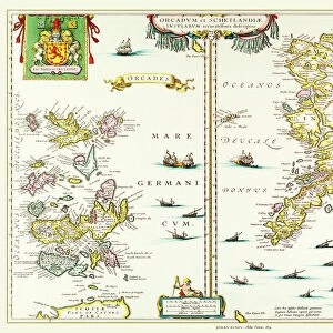
1818, Pinkerton Map of Jersey, Guernsey, Scilly and Shetland, British Isles, John Pinkerton

![]()
Wall Art and Photo Gifts from Liszt Collection
1818, Pinkerton Map of Jersey, Guernsey, Scilly and Shetland, British Isles, John Pinkerton
1818, Pinkerton Map of Jersey, Guernsey, Scilly and Shetland, British Isles, John Pinkerton, 1758 - 1826, Scottish antiquarian, cartographer, UK
Liszt Collection of nineteenth-century engravings and images to browse and enjoy
Media ID 14004966
© Artokoloro Quint Lox Limited
1758 1826 1758 – 1826 17581826 1818 Cartographer Guernsey John Pinkerton Scottish Antiquarian Antique Map Atlas British Isles Chart Geographic Latitude Longitude Mappa Mundi Old Antique Plan Old Antique View Old Map Ols Antique Map Rare Old Maps Topo
FEATURES IN THESE COLLECTIONS
> Europe
> United Kingdom
> Maps
> Europe
> United Kingdom
> Scotland
> Shetland
> Maps and Charts
> Early Maps
> Maps and Charts
> World
EDITORS COMMENTS
This print showcases the remarkable "1818, Pinkerton Map of Jersey, Guernsey, Scilly and Shetland" by John Pinkerton. As a Scottish antiquarian and cartographer, Pinkerton's expertise in topography and geography is evident in this meticulously crafted piece. The map encompasses the British Isles with intricate details that highlight the land's diverse features. The illustration exudes an air of vintage charm with its aged paper texture and retro aesthetic. Its historical significance takes us back to a time when exploration and discovery were at their peak. This ancient artifact serves as a window into the past, allowing us to delve into the rich history of these regions. With its precise grid lines depicting latitude and longitude, this map not only serves as a decorative piece but also offers practical navigation tools for those who study or appreciate cartography. It invites viewers on a journey through space and time, providing insight into how our world was perceived centuries ago. As one explores this rare old map from Pinkerton's collection, it becomes clear that it holds immense value for historians, geographers, or anyone fascinated by the intricacies of our planet's geography. Its artistic beauty combined with its historical significance makes it an exceptional addition to any collection or display dedicated to antique maps.
MADE IN THE USA
Safe Shipping with 30 Day Money Back Guarantee
FREE PERSONALISATION*
We are proud to offer a range of customisation features including Personalised Captions, Color Filters and Picture Zoom Tools
SECURE PAYMENTS
We happily accept a wide range of payment options so you can pay for the things you need in the way that is most convenient for you
* Options may vary by product and licensing agreement. Zoomed Pictures can be adjusted in the Cart.