Home > Europe > United Kingdom > Maps
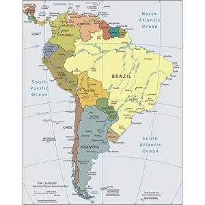
1818, Pinkerton Map of North America and South America, John Pinkerton, 1758 - 1826

![]()
Wall Art and Photo Gifts from Liszt Collection
1818, Pinkerton Map of North America and South America, John Pinkerton, 1758 - 1826
1818, Pinkerton Map of North America and South America, John Pinkerton, 1758 - 1826, Scottish antiquarian, cartographer, UK
Liszt Collection of nineteenth-century engravings and images to browse and enjoy
Media ID 14007026
© Artokoloro Quint Lox Limited
1758 1826 1758 – 1826 17581826 1818 Cartographer John Pinkerton Scottish Antiquarian Antique Map Atlas Chart Geographic Latitude Longitude Mappa Mundi Old Antique Plan Old Antique View Old Map Ols Antique Map Rare Old Maps Topo
FEATURES IN THESE COLLECTIONS
> Europe
> United Kingdom
> Maps
> Maps and Charts
> Early Maps
> Maps and Charts
> World
> North America
> Related Images
> South America
> Related Images
EDITORS COMMENTS
This print showcases the remarkable "1818, Pinkerton Map of North America and South America" created by the renowned Scottish antiquarian and cartographer, John Pinkerton. With a keen eye for detail and precision, Pinkerton meticulously crafted this map to provide an accurate representation of the two continents during that era. The map's topography is beautifully illustrated, capturing the diverse landscapes and geographical features that define North and South America. Its intricate grid system denotes latitude and longitude lines, allowing viewers to navigate through this historical masterpiece effortlessly. As one explores each corner of this vintage artifact, they are transported back in time to an age when exploration was at its peak. This ancient treasure holds immense historical significance as it not only serves as a navigational tool but also offers insights into the world as it existed centuries ago. The delicate artistry displayed on aged paper evokes a sense of nostalgia while reminding us of our planet's rich heritage. With its decorative elements and meticulous attention to detail, this rare old map stands as a testament to John Pinkerton's expertise in cartography. It invites viewers on a journey of discovery through uncharted territories while igniting curiosity about past civilizations. Whether you are an avid history enthusiast or simply appreciate fine craftsmanship, this antique map from 1818 is sure to captivate your imagination with its timeless beauty.
MADE IN THE USA
Safe Shipping with 30 Day Money Back Guarantee
FREE PERSONALISATION*
We are proud to offer a range of customisation features including Personalised Captions, Color Filters and Picture Zoom Tools
SECURE PAYMENTS
We happily accept a wide range of payment options so you can pay for the things you need in the way that is most convenient for you
* Options may vary by product and licensing agreement. Zoomed Pictures can be adjusted in the Cart.