Home > South America > Guyana > Maps
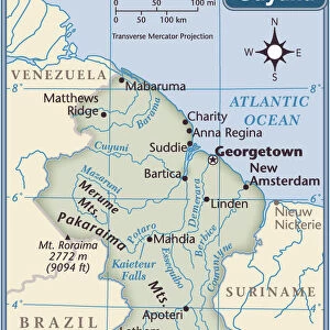
1818, Pinkerton Map of Northeastern South America, Venezuela, Guyana, Surinam, John Pinkerton

![]()
Wall Art and Photo Gifts from Liszt Collection
1818, Pinkerton Map of Northeastern South America, Venezuela, Guyana, Surinam, John Pinkerton
1818, Pinkerton Map of Northeastern South America, Venezuela, Guyana, Surinam, John Pinkerton, 1758 - 1826, Scottish antiquarian, cartographer, UK
Liszt Collection of nineteenth-century engravings and images to browse and enjoy
Media ID 14004968
© Artokoloro Quint Lox Limited
1758 1826 1758 – 1826 17581826 1818 Cartographer Guyana John Pinkerton Scottish Antiquarian Venezuela Antique Map Atlas Chart Geographic Latitude Longitude Mappa Mundi Old Antique Plan Old Antique View Old Map Ols Antique Map Rare Old Maps Surinam Topo
FEATURES IN THESE COLLECTIONS
> Europe
> United Kingdom
> Maps
> Maps and Charts
> Early Maps
> Maps and Charts
> World
> South America
> Guyana
> Maps
> South America
> Venezuela
> Maps
EDITORS COMMENTS
This print showcases the exquisite 1818 Pinkerton Map of Northeastern South America, a remarkable creation by Scottish antiquarian and cartographer John Pinkerton. With meticulous attention to detail, this vintage map offers an intricate depiction of Venezuela, Guyana, and Surinam, providing a glimpse into the region's rich topography and geography. As we delve into this historical piece of art, we are transported back in time to an era when exploration and discovery were at their peak. The carefully illustrated landforms and geographic features invite us to embark on a journey through uncharted territories. This ancient map serves as a window into the past, revealing how our understanding of the world has evolved over centuries. The faded hues and aged appearance add a touch of nostalgia to this decorative piece. Its presence evokes a sense of wonderment about the brave souls who traversed these lands long ago. Whether used for navigation or simply admired for its beauty, this rare old map holds immense historical value. With its delicate lines forming grids of latitude and longitude, it reminds us that cartography is not merely about plotting locations but also about capturing the essence of different regions. As we gaze upon this antique treasure from the Liszt Collection, we are reminded that maps transcend time; they connect us with our past while guiding us towards new horizons in our own journeys through life.
MADE IN THE USA
Safe Shipping with 30 Day Money Back Guarantee
FREE PERSONALISATION*
We are proud to offer a range of customisation features including Personalised Captions, Color Filters and Picture Zoom Tools
SECURE PAYMENTS
We happily accept a wide range of payment options so you can pay for the things you need in the way that is most convenient for you
* Options may vary by product and licensing agreement. Zoomed Pictures can be adjusted in the Cart.