Home > Europe > United Kingdom > Scotland > Maps
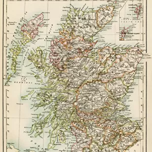
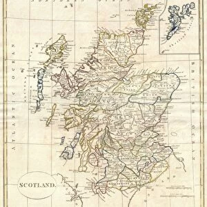
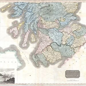
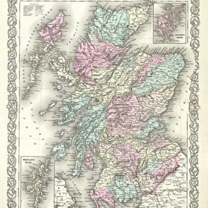
1818, Pinkerton Map of Northern Scotland, John Pinkerton, 1758 - 1826, Scottish antiquarian

![]()
Wall Art and Photo Gifts from Liszt Collection
1818, Pinkerton Map of Northern Scotland, John Pinkerton, 1758 - 1826, Scottish antiquarian
1818, Pinkerton Map of Northern Scotland, John Pinkerton, 1758 - 1826, Scottish antiquarian, cartographer, UK
Liszt Collection of nineteenth-century engravings and images to browse and enjoy
Media ID 14007028
© Artokoloro Quint Lox Limited
1758 1826 1758 – 1826 17581826 1818 Cartographer John Pinkerton Scottish Antiquarian Antique Map Atlas Chart Geographic Latitude Longitude Mappa Mundi Old Antique Plan Old Antique View Old Map Ols Antique Map Rare Old Maps Topo
FEATURES IN THESE COLLECTIONS
> Europe
> United Kingdom
> Maps
> Europe
> United Kingdom
> Scotland
> Maps
> Maps and Charts
> Early Maps
> Maps and Charts
> World
EDITORS COMMENTS
This print showcases the remarkable "1818, Pinkerton Map of Northern Scotland" created by John Pinkerton, a renowned Scottish antiquarian and cartographer. With meticulous attention to detail, Pinkerton skillfully crafted this map to depict the topography, geography, and land features of Northern Scotland during that era. The vintage charm emanating from this ancient piece of art takes us on a journey back in time. Its aged appearance adds an element of historical significance and authenticity. The delicate lines forming a grid system reveal the precise latitude and longitude coordinates, enabling accurate navigation across the region. As we explore this decorative map's intricate illustrations, we are transported into a world where discovery and exploration were paramount. This rare antique map not only serves as an invaluable tool for understanding historical geography but also offers insights into how people perceived their surroundings centuries ago. Printed on high-quality paper with exquisite craftsmanship, this old-world treasure is truly a collector's item. It evokes nostalgia for times long gone while reminding us of our connection to Earth's rich history. Whether you are an avid historian or simply appreciate fine artistry, this Pinkerton Map will undoubtedly captivate your imagination. Display it proudly in your home or office as both a conversation starter and a testament to human curiosity about our world throughout different epochs.
MADE IN THE USA
Safe Shipping with 30 Day Money Back Guarantee
FREE PERSONALISATION*
We are proud to offer a range of customisation features including Personalised Captions, Color Filters and Picture Zoom Tools
SECURE PAYMENTS
We happily accept a wide range of payment options so you can pay for the things you need in the way that is most convenient for you
* Options may vary by product and licensing agreement. Zoomed Pictures can be adjusted in the Cart.