Home > South America > Ecuador > Maps
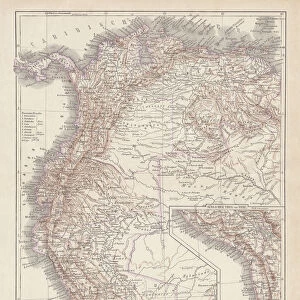
1818, Pinkerton Map of Northwestern South America, Columbia, Venezuela, Ecuador, Panama

![]()
Wall Art and Photo Gifts from Liszt Collection
1818, Pinkerton Map of Northwestern South America, Columbia, Venezuela, Ecuador, Panama
1818, Pinkerton Map of Northwestern South America, Columbia, Venezuela, Ecuador, Panama, John Pinkerton, 1758 - 1826, Scottish antiquarian, cartographer, UK
Liszt Collection of nineteenth-century engravings and images to browse and enjoy
Media ID 14004973
© Artokoloro Quint Lox Limited
1758 1826 1758 – 1826 17581826 1818 Cartographer Columbia Ecuador John Pinkerton Panama Scottish Antiquarian Venezuela Antique Map Atlas Chart Geographic Latitude Longitude Mappa Mundi Old Antique Plan Old Antique View Old Map Ols Antique Map Rare Old Maps Topo
FEATURES IN THESE COLLECTIONS
> Europe
> United Kingdom
> Maps
> Maps and Charts
> Early Maps
> Maps and Charts
> World
> North America
> Panama
> Maps
> South America
> Ecuador
> Maps
> South America
> Venezuela
> Maps
EDITORS COMMENTS
This print showcases the remarkable "1818, Pinkerton Map of Northwestern South America". Created by John Pinkerton, a renowned Scottish antiquarian and cartographer, this vintage map offers a fascinating glimpse into the geography and topography of Columbia, Venezuela, Ecuador, and Panama during that era. With its intricate details and precise measurements of latitude and longitude, this map serves as both an informative tool for navigation and an exquisite piece of art. The aged appearance adds to its historical charm, evoking a sense of discovery and exploration in a time long past. The delicate illustrations depict various regions with accuracy while showcasing the vastness of the world at that time. This rare antique map is truly a treasure for any history enthusiast or collector. As we gaze upon this ancient artifact from centuries ago, we are transported back in time to an era when cartography was not only practical but also considered an art form. Its decorative elements make it not just a mere representation of land but also an aesthetic masterpiece. The Liszt Collection has beautifully preserved this old antique plan so that we can appreciate its significance today. Whether you are interested in studying historical maps or simply enjoy admiring their beauty, this print is sure to captivate your imagination with its rich history and artistic allure.
MADE IN THE USA
Safe Shipping with 30 Day Money Back Guarantee
FREE PERSONALISATION*
We are proud to offer a range of customisation features including Personalised Captions, Color Filters and Picture Zoom Tools
SECURE PAYMENTS
We happily accept a wide range of payment options so you can pay for the things you need in the way that is most convenient for you
* Options may vary by product and licensing agreement. Zoomed Pictures can be adjusted in the Cart.