Home > South America > Bolivia > Maps
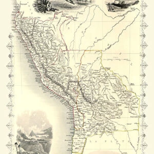
1818, Pinkerton Map of of La Plata, Southern South America, Argentina, Chile, Bolivia

![]()
Wall Art and Photo Gifts from Liszt Collection
1818, Pinkerton Map of of La Plata, Southern South America, Argentina, Chile, Bolivia
1818, Pinkerton Map of of La Plata, Southern South America, Argentina, Chile, Bolivia, John Pinkerton, 1758 - 1826, Scottish antiquarian, cartographer, UK
Liszt Collection of nineteenth-century engravings and images to browse and enjoy
Media ID 14004979
© Artokoloro Quint Lox Limited
1758 1826 1758 – 1826 17581826 1818 Argentina Bolivia Cartographer Chile John Pinkerton Scottish Antiquarian Antique Map Atlas Chart Geographic Latitude Longitude Mappa Mundi Old Antique Plan Old Antique View Old Map Ols Antique Map Rare Old Maps Topo
FEATURES IN THESE COLLECTIONS
> Europe
> United Kingdom
> Maps
> Maps and Charts
> Early Maps
> Maps and Charts
> World
> South America
> Argentina
> La Plata
> South America
> Argentina
> Maps
> South America
> Bolivia
> Maps
> South America
> Chile
> Maps
EDITORS COMMENTS
This vintage print showcases the remarkable 1818 Pinkerton Map of La Plata, Southern South America. Created by John Pinkerton, a renowned Scottish antiquarian and cartographer, this map offers a captivating glimpse into the geography and topography of Argentina, Chile, Bolivia, and surrounding regions during that era. With its intricate details and precise measurements, this historic piece serves as an invaluable resource for understanding the land's layout in the early 19th century. The carefully drawn lines depict latitude and longitude coordinates while highlighting various geographic features such as mountains, rivers, and coastlines. The artistry behind this map is evident in its decorative elements that evoke a sense of nostalgia. Its aged appearance adds to its charm as it transports us back to a time when exploration and discovery were at their peak. This antique map not only provides historical context but also invites us on a journey through time. As we gaze upon this rare relic from centuries past, we are reminded of how maps have long been essential tools for navigation and understanding our world. It serves as a testament to human curiosity about distant lands and our desire to document them accurately. Whether you are an avid collector or simply appreciate the beauty of historical artifacts, this Pinkerton Map print is sure to captivate your imagination with its rich history and timeless allure.
MADE IN THE USA
Safe Shipping with 30 Day Money Back Guarantee
FREE PERSONALISATION*
We are proud to offer a range of customisation features including Personalised Captions, Color Filters and Picture Zoom Tools
SECURE PAYMENTS
We happily accept a wide range of payment options so you can pay for the things you need in the way that is most convenient for you
* Options may vary by product and licensing agreement. Zoomed Pictures can be adjusted in the Cart.