Home > Europe > Poland > Maps
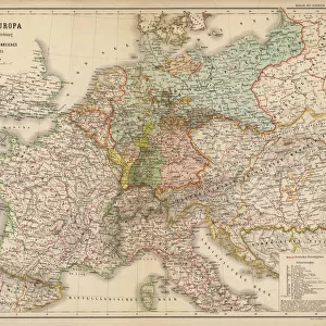
1818, Pinkerton Map of Poland, John Pinkerton, 1758 - 1826, Scottish antiquarian

![]()
Wall Art and Photo Gifts from Liszt Collection
1818, Pinkerton Map of Poland, John Pinkerton, 1758 - 1826, Scottish antiquarian
1818, Pinkerton Map of Poland, John Pinkerton, 1758 - 1826, Scottish antiquarian, cartographer, UK
Liszt Collection of nineteenth-century engravings and images to browse and enjoy
Media ID 14007034
© Artokoloro Quint Lox Limited
1758 1826 1758 – 1826 17581826 1818 Cartographer John Pinkerton Scottish Antiquarian Antique Map Atlas Chart Geographic Latitude Longitude Mappa Mundi Old Antique Plan Old Antique View Old Map Ols Antique Map Rare Old Maps Topo
FEATURES IN THESE COLLECTIONS
> Europe
> United Kingdom
> Maps
> Maps and Charts
> Early Maps
> Maps and Charts
> World
EDITORS COMMENTS
This print showcases the exquisite "1818, Pinkerton Map of Poland" created by John Pinkerton, a renowned Scottish antiquarian and cartographer. With his expert craftsmanship, Pinkerton meticulously crafted this map to depict the topography, geography, and land formations of Poland during that era. The vintage allure of this ancient map is evident in its intricate details and historical significance. Its yellowed paper texture adds an extra layer of charm, transporting viewers back in time to explore the world as it was centuries ago. The artistry behind this decorative piece is truly remarkable; every line and contour has been carefully etched onto its surface. As we gaze upon this rare old map, we are reminded of the journey and discovery that early explorers embarked upon to uncover new regions across the globe. The grid-like chart with latitude and longitude coordinates serves as a guide for navigation through uncharted territories. This antique treasure not only offers a glimpse into Poland's past but also provides us with insights into how our understanding of geography has evolved over time. It stands as a testament to John Pinkerton's dedication to preserving history through his exceptional cartographic skills. Whether you are an avid collector or simply appreciate the beauty of historical artifacts, this stunning print from Liszt Collection will undoubtedly captivate your imagination and transport you on a visual expedition through time.
MADE IN THE USA
Safe Shipping with 30 Day Money Back Guarantee
FREE PERSONALISATION*
We are proud to offer a range of customisation features including Personalised Captions, Color Filters and Picture Zoom Tools
SECURE PAYMENTS
We happily accept a wide range of payment options so you can pay for the things you need in the way that is most convenient for you
* Options may vary by product and licensing agreement. Zoomed Pictures can be adjusted in the Cart.