Home > Europe > United Kingdom > Maps
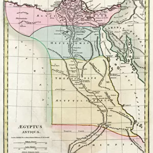
1818, Pinkerton Map of Southern Africa, Congo, Monomotapa, Cape Colony, John Pinkerton

![]()
Wall Art and Photo Gifts from Liszt Collection
1818, Pinkerton Map of Southern Africa, Congo, Monomotapa, Cape Colony, John Pinkerton
1818, Pinkerton Map of Southern Africa, Congo, Monomotapa, Cape Colony, John Pinkerton, 1758 - 1826, Scottish antiquarian, cartographer, UK
Liszt Collection of nineteenth-century engravings and images to browse and enjoy
Media ID 14004976
© Artokoloro Quint Lox Limited
1758 1826 1758 – 1826 17581826 1818 Cape Colony Cartographer Congo John Pinkerton Scottish Antiquarian Antique Map Atlas Chart Geographic Latitude Longitude Mappa Mundi Old Antique Plan Old Antique View Old Map Ols Antique Map Rare Old Maps Topo
FEATURES IN THESE COLLECTIONS
> Africa
> Related Images
> Europe
> United Kingdom
> Maps
> Maps and Charts
> Early Maps
> Maps and Charts
> World
EDITORS COMMENTS
This print showcases the remarkable "1818, Pinkerton Map of Southern Africa, Congo, Monomotapa, Cape Colony" created by the renowned Scottish antiquarian and cartographer, John Pinkerton. With a keen eye for detail and precision, Pinkerton meticulously crafted this map to provide an intricate depiction of the region's topography and geography. The vintage allure of this ancient map is evident in its aged appearance and historical significance. Its delicate lines form a mesmerizing grid that reveals latitude and longitude coordinates with geometric accuracy. As one explores this artistic piece, they are transported back in time to an era when exploration and discovery were at their peak. The paper texture adds to the charm of this decorative artwork as it evokes a sense of nostalgia for old-world navigation techniques. This rare antique map serves as a testament to human curiosity about our planet's vast landscapes throughout history. Whether you are an avid traveler or simply fascinated by cartography, this exquisite print from the Liszt Collection offers a glimpse into Southern Africa's past. It invites viewers on a journey through time while celebrating the artistry behind creating maps that were once essential tools for explorers venturing into uncharted territories.
MADE IN THE USA
Safe Shipping with 30 Day Money Back Guarantee
FREE PERSONALISATION*
We are proud to offer a range of customisation features including Personalised Captions, Color Filters and Picture Zoom Tools
SECURE PAYMENTS
We happily accept a wide range of payment options so you can pay for the things you need in the way that is most convenient for you
* Options may vary by product and licensing agreement. Zoomed Pictures can be adjusted in the Cart.