Home > Europe > United Kingdom > England > Maps
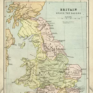
1818, Pinkerton Map of Southern England, includes London, John Pinkerton, 1758 - 1826

![]()
Wall Art and Photo Gifts from Liszt Collection
1818, Pinkerton Map of Southern England, includes London, John Pinkerton, 1758 - 1826
1818, Pinkerton Map of Southern England, includes London, John Pinkerton, 1758 - 1826, Scottish antiquarian, cartographer, UK
Liszt Collection of nineteenth-century engravings and images to browse and enjoy
Media ID 14004985
© Artokoloro Quint Lox Limited
1758 1826 1758 – 1826 17581826 1818 Cartographer John Pinkerton Scottish Antiquarian Antique Map Atlas Chart Geographic Latitude Longitude Mappa Mundi Old Antique Plan Old Antique View Old Map Ols Antique Map Rare Old Maps Topo
FEATURES IN THESE COLLECTIONS
> Europe
> United Kingdom
> England
> London
> Related Images
> Europe
> United Kingdom
> England
> Maps
> Europe
> United Kingdom
> Maps
> Maps and Charts
> Early Maps
> Maps and Charts
> World
EDITORS COMMENTS
This print showcases the remarkable "1818, Pinkerton Map of Southern England, includes London" by John Pinkerton. Born in 1758 and passing away in 1826, Pinkerton was a Scottish antiquarian and cartographer renowned for his exceptional contributions to the field of geography. The map itself is a true work of art, meticulously illustrating the topography and geographic features of southern England. With its intricate details and precise measurements, it serves as an invaluable resource for travelers, historians, and enthusiasts alike. Transporting us back to a bygone era, this vintage piece exudes an air of ancient history. The aged paper adds an authentic touch while evoking a sense of nostalgia. Its decorative elements make it not only informative but also aesthetically pleasing. As we gaze upon this rare old map from the Liszt Collection, we are reminded of the importance placed on navigation and exploration during that time period. It offers us a glimpse into how people perceived their world centuries ago – with wonderment and curiosity about distant lands yet to be discovered. Whether you're fascinated by cartography or simply appreciate historical artifacts, this antique map transports you on a journey through time. It captures both the beauty and significance of maps as tools for understanding our planet's past while igniting our imagination for future adventures yet to come.
MADE IN THE USA
Safe Shipping with 30 Day Money Back Guarantee
FREE PERSONALISATION*
We are proud to offer a range of customisation features including Personalised Captions, Color Filters and Picture Zoom Tools
SECURE PAYMENTS
We happily accept a wide range of payment options so you can pay for the things you need in the way that is most convenient for you
* Options may vary by product and licensing agreement. Zoomed Pictures can be adjusted in the Cart.