Home > Europe > Greece > Maps
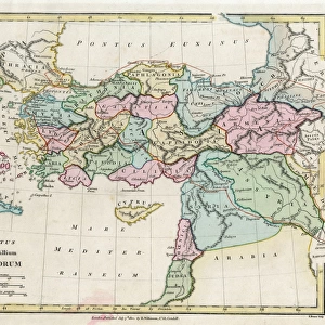
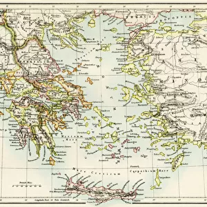
1818, Pinkerton Map of Turkey in Europe, Greece andamp, the Balkans, John Pinkerton

![]()
Wall Art and Photo Gifts from Liszt Collection
1818, Pinkerton Map of Turkey in Europe, Greece andamp, the Balkans, John Pinkerton
1818, Pinkerton Map of Turkey in Europe, Greece andamp, the Balkans, John Pinkerton, 1758 - 1826, Scottish antiquarian, cartographer, UK
Liszt Collection of nineteenth-century engravings and images to browse and enjoy
Media ID 14005004
© Artokoloro Quint Lox Limited
1758 1826 1758 – 1826 17581826 1818 Cartographer John Pinkerton Scottish Antiquarian Antique Map Atlas Chart Geographic Latitude Longitude Mappa Mundi Old Antique Plan Old Antique View Old Map Ols Antique Map Rare Old Maps The Balkans Topo
FEATURES IN THESE COLLECTIONS
> Asia
> Turkey
> Related Images
> Europe
> United Kingdom
> Maps
> Maps and Charts
> Early Maps
> Maps and Charts
> World
EDITORS COMMENTS
This print showcases the remarkable "1818, Pinkerton Map of Turkey in Europe, Greece and the Balkans" by John Pinkerton. A Scottish antiquarian and esteemed cartographer, Pinkerton's expertise is evident in this meticulously crafted piece. The map encompasses a vast expanse of land, providing an intricate depiction of topography, geography, and travel routes. The vintage allure of this ancient map transports us back to a time when exploration was at its peak. Its aged appearance adds a touch of historical charm while reminding us of the rich tapestry that is our world's past. With delicate lines forming a precise grid system based on latitude and longitude coordinates, it serves as both an artful illustration and a practical navigational tool. As we delve into its details, we are invited to embark on a journey through time and space. This rare antique map offers invaluable insight into the region's history and cultural significance. It allows us to trace the footsteps of explorers who ventured across these lands centuries ago. Adorned with decorative elements that enhance its aesthetic appeal, this print captures not only the essence of cartography but also serves as an artistic masterpiece in itself. Whether displayed for educational purposes or simply admired for its beauty, this exquisite print from Liszt Collection brings together history enthusiasts and art lovers alike in their appreciation for our planet's diverse heritage.
MADE IN THE USA
Safe Shipping with 30 Day Money Back Guarantee
FREE PERSONALISATION*
We are proud to offer a range of customisation features including Personalised Captions, Color Filters and Picture Zoom Tools
SECURE PAYMENTS
We happily accept a wide range of payment options so you can pay for the things you need in the way that is most convenient for you
* Options may vary by product and licensing agreement. Zoomed Pictures can be adjusted in the Cart.