Home > Animals > Mammals > Soricidae > Niger
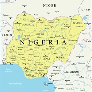
1818, Pinkerton Map of Western Africa, Niger Valley, Mountains of Kong, John Pinkerton

![]()
Wall Art and Photo Gifts from Liszt Collection
1818, Pinkerton Map of Western Africa, Niger Valley, Mountains of Kong, John Pinkerton
1818, Pinkerton Map of Western Africa, Niger Valley, Mountains of Kong, John Pinkerton, 1758 - 1826, Scottish antiquarian, cartographer, UK
Liszt Collection of nineteenth-century engravings and images to browse and enjoy
Media ID 14005003
© Artokoloro Quint Lox Limited
1758 1826 1758 – 1826 17581826 1818 Cartographer John Pinkerton Scottish Antiquarian Antique Map Atlas Chart Geographic Latitude Longitude Mappa Mundi Old Antique Plan Old Antique View Old Map Ols Antique Map Rare Old Maps Topo
FEATURES IN THESE COLLECTIONS
> Animals
> Mammals
> Soricidae
> Niger
> Europe
> United Kingdom
> Maps
> Maps and Charts
> Early Maps
> Maps and Charts
> World
EDITORS COMMENTS
This print showcases the intricate and historically significant "1818, Pinkerton Map of Western Africa". Created by John Pinkerton, a renowned Scottish antiquarian and cartographer, this map offers an invaluable glimpse into the geography and topography of the Niger Valley and Mountains of Kong in Western Africa. The detailed illustration on this vintage map highlights the meticulous craftsmanship that went into its creation. With precise grids indicating latitude and longitude, it serves as a reliable navigational tool for explorers during that era. The faded paper adds to its charm, evoking a sense of history and nostalgia. As we delve into this ancient cartographic gem, we are transported back in time to an era when exploration was at its peak. This rare old map not only provides us with geographical insights but also acts as a portal to understanding past civilizations' journeys of discovery. With its decorative elements and artistic flair, this historical artifact is not just a mere representation of land but also an embodiment of human curiosity about our world's vastness. It reminds us that maps hold stories within them—stories waiting to be unraveled by those who dare to explore. Whether you're an avid collector or simply intrigued by history's mysteries, this antique map from John Pinkerton is sure to captivate your imagination with its rich heritage and timeless allure.
MADE IN THE USA
Safe Shipping with 30 Day Money Back Guarantee
FREE PERSONALISATION*
We are proud to offer a range of customisation features including Personalised Captions, Color Filters and Picture Zoom Tools
SECURE PAYMENTS
We happily accept a wide range of payment options so you can pay for the things you need in the way that is most convenient for you
* Options may vary by product and licensing agreement. Zoomed Pictures can be adjusted in the Cart.