Home > Europe > United Kingdom > Maps
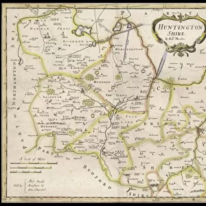
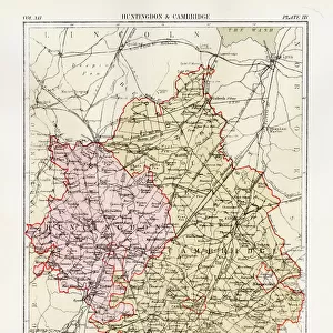
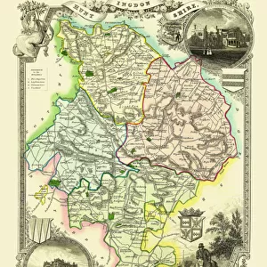
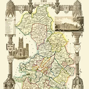
Cambridgeshire map, A Topographical Dictionary of the United Kingdom, UK, 19th century

![]()
Wall Art and Photo Gifts from Liszt Collection
Cambridgeshire map, A Topographical Dictionary of the United Kingdom, UK, 19th century
Cambridgeshire map, A Topographical Dictionary of the United Kingdom, UK, 19th century engraving
Liszt Collection of nineteenth-century engravings and images to browse and enjoy
Media ID 12805549
© Quint Lox Limited
Cambridgeshire Topographical Dictionary United Kingdom
FEATURES IN THESE COLLECTIONS
> Europe
> United Kingdom
> England
> Cambridgeshire
> Related Images
> Europe
> United Kingdom
> Maps
EDITORS COMMENTS
This 19th-century engraving of the Cambridgeshire map is a true testament to the rich history and intricate beauty of this region in the United Kingdom. As part of A Topographical Dictionary of the United Kingdom, this print offers a glimpse into an era long gone, where hand-drawn maps were meticulously crafted with utmost precision. The detailed topography showcased in this print allows us to explore every nook and cranny of Cambridgeshire's diverse landscape. From its rolling hills and lush meadows to its winding rivers and charming villages, each element on this map tells a story waiting to be discovered. As we delve into the past through this enchanting piece, we can imagine how life must have been for the inhabitants of Cambridgeshire during that time. The hustle and bustle of market towns, the tranquility found in nature's embrace, and perhaps even some hidden secrets tucked away within these ancient borders. Beyond its historical significance, this print from Liszt Collection serves as a reminder that our world is ever-evolving. It prompts us to reflect on how far we have come since those days when maps like these were essential tools for exploration and navigation. Whether you are an avid historian or simply appreciate artistry at its finest, let your imagination wander as you gaze upon this remarkable engraving—a window into both Cambridgeshire's past and our own fascination with preserving history for generations to come.
MADE IN THE USA
Safe Shipping with 30 Day Money Back Guarantee
FREE PERSONALISATION*
We are proud to offer a range of customisation features including Personalised Captions, Color Filters and Picture Zoom Tools
SECURE PAYMENTS
We happily accept a wide range of payment options so you can pay for the things you need in the way that is most convenient for you
* Options may vary by product and licensing agreement. Zoomed Pictures can be adjusted in the Cart.