Home > Oceania > Australia > Maps
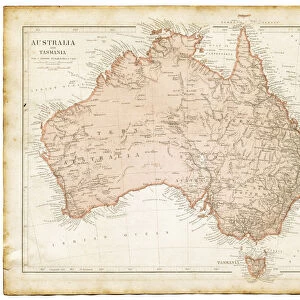
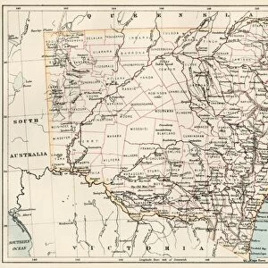
Australia Map Gotha, Justus Perthes, 1872, Atlas

![]()
Wall Art and Photo Gifts from Liszt Collection
Australia Map Gotha, Justus Perthes, 1872, Atlas
Australia Map Gotha, Justus Perthes, 1872, Atlas. Perthes, Johan Georg Justus 1749 aa 1816, German publisher, was born in Rudolstadt in 1749. In 1785 he founded at Gotha the business which bears his name, Justus Perthes. In this he was joined in 1814 by his son Wilhelm, 1793 aa 1853. He laid the foundation of the Geographical Branch of the business, for which it is chiefly famous, by publishing the and-Atlas (1817-1823) of Adolf Stieler (1775-1836). Wilhelm Perthes engaged the collaboration of the most eminent German geographers of the time, including Heinrich Berghaus, Christian Gottlieb Reichard, Karl Spruler and Emil von Sydow. The business passed to his son Bernard Wilhelm Perthes (1821-1857). In 1863 the firm first issued the Almanach de Gotha, a statistical, Historical and genealogical Annual (in French) of the various countries of the world
Liszt Collection of nineteenth-century engravings and images to browse and enjoy
Media ID 12958909
© Quint Lox Limited
1872 Allemagne Book Of Maps Bundesrepublik Deutschland D Allemagne D,allemagne Deutschland Erfurt German Publisher Gotha Johan Georg Justus 1749 – 1816 Johan Georg Justus 17491816 Justus Perthes Liszt Collection Perthes Republica Federal De Alemania Thuringia Atlas
FEATURES IN THESE COLLECTIONS
> Liszt Collection
> Engravings
> Maps and Charts
> Early Maps
> Maps and Charts
> Related Images
> Maps and Charts
> World
> Oceania
> Australia
> Related Images
EDITORS COMMENTS
This vintage print showcases the Australia Map Gotha, a remarkable piece of cartographic history from 1872. Published by Justus Perthes, a renowned German publisher, this map is part of an atlas that bears his name. Justus Perthes founded his business in Gotha in 1785 and was later joined by his son Wilhelm in 1814. Together, they laid the foundation for the Geographical Branch of their business, which became famous for publishing Adolf Stieler's And-Atlas. Wilhelm Perthes collaborated with esteemed German geographers of the time to create this exceptional map. The intricate engravement technique used brings out every detail of Australia's geography and topography. This historical artifact represents a significant milestone in cartography and serves as a testament to the skill and dedication of its creators. The Liszt Collection has preserved this image beautifully, capturing its retro charm and Victorian-era aesthetics. As we gaze upon this piece, we are transported back to a time when maps were meticulously crafted works of art rather than digital representations on screens. Let us appreciate not only the beauty but also the historical significance encapsulated within this Australia Map Gotha from 1872 – an invaluable resource for understanding our world's past geographical knowledge.
MADE IN THE USA
Safe Shipping with 30 Day Money Back Guarantee
FREE PERSONALISATION*
We are proud to offer a range of customisation features including Personalised Captions, Color Filters and Picture Zoom Tools
SECURE PAYMENTS
We happily accept a wide range of payment options so you can pay for the things you need in the way that is most convenient for you
* Options may vary by product and licensing agreement. Zoomed Pictures can be adjusted in the Cart.