Home > Europe > United Kingdom > England > London > Related Images
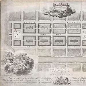
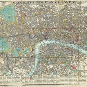
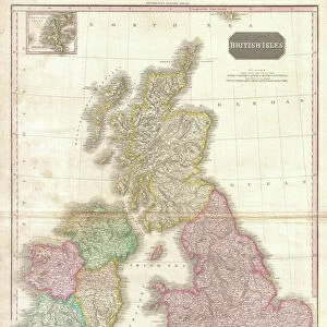
Old Map of London

![]()
Wall Art and Photo Gifts from Liszt Collection
Old Map of London
OLD MAP OF LONDON
Liszt Collection of nineteenth-century engravings and images to browse and enjoy
Media ID 12980525
© Quint Lox Limited
FEATURES IN THESE COLLECTIONS
> Europe
> United Kingdom
> England
> London
> Related Images
> Liszt Collection
> Engravings
> Maps and Charts
> Related Images
EDITORS COMMENTS
This print titled "Old Map of London" takes us on a nostalgic journey back to the nineteenth century. The intricately engraved image showcases the rich history and cultural heritage of one of the world's most iconic cities. With its vintage, retro-styled charm, this piece is a true testament to the illustrative techniques and engravement skills prevalent during the Victorian era. The map itself is a treasure trove of information, offering a detailed plan and chart of London as it existed in times gone by. Every street, alleyway, and landmark is meticulously depicted, allowing us to explore the city's past with awe-inspiring accuracy. As we gaze upon this historical artifact, we are transported back in time to an era where horse-drawn carriages roamed these very streets. The Old Map of London serves not only as a decorative piece but also as an educational tool that invites us to delve into our collective past. It sparks curiosity about how life must have been for those who walked these same paths centuries ago. This print from Liszt Collection captures both the essence and spirit of old-world arts and culture. Whether you're an avid historian or simply appreciate beautiful artwork with a touch of nostalgia, this enchanting print will surely captivate your imagination. Display it proudly in your home or office space - let it be a conversation starter that transports you through time while celebrating London's enduring legacy.
MADE IN THE USA
Safe Shipping with 30 Day Money Back Guarantee
FREE PERSONALISATION*
We are proud to offer a range of customisation features including Personalised Captions, Color Filters and Picture Zoom Tools
SECURE PAYMENTS
We happily accept a wide range of payment options so you can pay for the things you need in the way that is most convenient for you
* Options may vary by product and licensing agreement. Zoomed Pictures can be adjusted in the Cart.