Fraud Blocker Skip to main content

Home > Africa > Sudan > Maps

Source Size = 1824 x 2744

Source Size = 1824 x 2744


Framed Photos
Photo Prints
Jigsaw Puzzles
Poster Prints
Canvas Prints
Fine Art Prints
Metal Prints
Home Decor


We accept all major credit cards

Liszt Collection

Wall Art and Photo Gifts from Liszt Collection

Source Size = 1824 x 2744

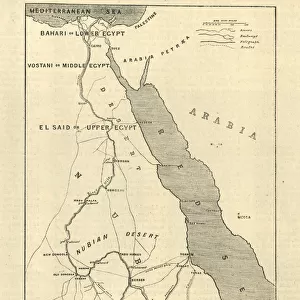
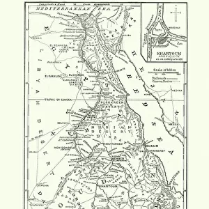
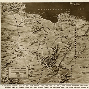
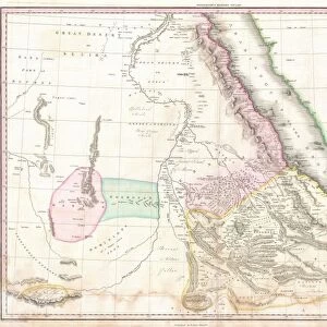
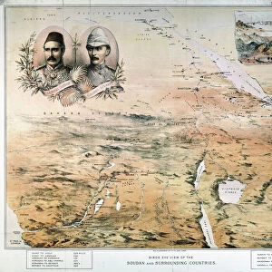
The Rebellion in the Soudan (Sudan): Map Showing Upper Egypt and the Seat of the Revolt, the Routes Across the Desert to Khartoum, and the Towns where Egyptian Garrisons are Beleaguered

Liszt Collection of nineteenth-century engravings and images to browse and enjoy

Media ID 12972539

© Quint Lox Limited

Abandon Desert Egyptian Insurrection Khartoum Leave Plan Rebellion Revolt Seat Showing Soudan Sudan Towns Upper Uprising Beleaguered Chart Routes


FEATURES IN THESE COLLECTIONS

> Africa > Egypt > Maps

> Africa > Sudan > Khartoum

> Africa > Sudan > Maps

> Liszt Collection > Engravings

> Maps and Charts > Related Images


EDITORS COMMENTS
This vintage print titled "The Rebellion in the Soudan: Map Showing Upper Egypt and the Seat of the Revolt" takes us back to a significant period in history. The intricately engraved image, with its retro-styled charm, offers a glimpse into the insurrection that unfolded in Sudan during Victorian times. With a source size of 1824 x 2744 pixels, this print showcases an illustrative technique that brings to life the rebellion's key elements. The detailed map highlights not only Upper Egypt but also Khartoum, where Egyptian garrisons faced immense challenges from rebellious forces. It meticulously outlines the routes across the desert that were used by both sides during this tumultuous time. The visual narrative captures the tension and turmoil of an uprising as towns are beleaguered and Egyptian garrisons find themselves isolated and under siege. This historical artifact serves as a valuable resource for those interested in studying this pivotal event. As we gaze upon this evocative piece from Liszt Collection's archives, it reminds us of how art can preserve moments from our past. It transports us to another era while offering insights into cultural perspectives and artistic techniques prevalent at that time.

MADE IN THE USA
Safe Shipping with 30 Day Money Back Guarantee

FREE PERSONALISATION*
We are proud to offer a range of customisation features including Personalised Captions, Color Filters and Picture Zoom Tools

SECURE PAYMENTS
We happily accept a wide range of payment options so you can pay for the things you need in the way that is most convenient for you

* Options may vary by product and licensing agreement. Zoomed Pictures can be adjusted in the Cart.


redeem
Beautiful Photo Prints and Gifts
image
Professionally Printed
inventory
Photo Prints are in stock
thumb_up
Professional quality finish
diamond
Made with high-grade materials
inventory_2
Carefully packed to aid safe arrival


Related Images


Victorian Map of Africa
Map Of Egypt, Sudan, 1899
Mahdist War, Map of the rebellion in Sudan, 1884
Map Showing The Battle Of Atbara During The Second Sudan War Also Called The Mahdist War, The Mahdist Revolt, Anglo-Sudan War Or The Sudanese Mahdist Revolt, 1898. From Field Marshal Lord Kitchener, His Life And Work For The Empire, Published 1916
Map Of The Battle Of Omdurman, Khartoum, Sudan, 1898, Showing The 1st Attack At 6. 45 A. m. And The Khalifas Attack At 9. 40 A. m. From Field Marshal Lord Kitchener, His Life And Work For The Empire, Published 1916
Kartoum Sudan In 1884 Drawn From Rough Sketches Made By General Gordon From The Journals Of Major-Gen. C. G. Gordon C. B. At Kartoum Published By Kegan Paul Trench & Co London 1885
Map of Sudan, late 19th Century
Telegraph map of Upper Egypt
Map of the war in North Africa by G. H. Davis
Map Egypt and Sudan
Map Egypt and Sudan
1818, Pinkerton Map of Nubia, Sudan and Abyssinia, John Pinkerton, 1758 - 1826, Scottish
1771, Bonne Map of Abyssinia, Ethiopia, Sudan and the Red Sea, Rigobert Bonne 1727 - 1794

+

Shipping

+

Choices

+

Reviews

+

Guaranteed


Related Collections


Engravings
Engravings
Browse 13,015 Prints
Khartoum
Khartoum
Browse 328 Prints
Maps
Maps
Browse 447 Prints
Maps
Maps
Browse 177 Prints
Maps and Charts Related Images
Browse 13,753 Prints