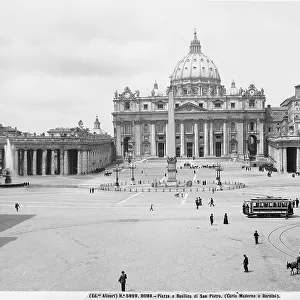
Home > Europe > Italy > Lazio > Rome
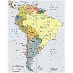
Map of the West Indies, Caribbean Sea, Antilles, 1709-1713 (engraving)
")
![]()
Wall Art and Photo Gifts from Fine Art Finder
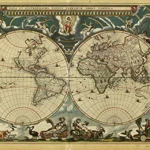
Map of the West Indies, Caribbean Sea, Antilles, 1709-1713 (engraving)
VEN5030086 Map of the West Indies, Caribbean Sea, Antilles, 1709-1713 (engraving) by Keulen, Gerard van (1678-1726); Biblioteca Angelica, Rome, Italy; (add.info.: Geography map: view of the West Indies, Caribbean Sea, West Indies (Cuba, Hispaniola, Jamaica, Puerto Rico and the Lesser Antilles), the Bahamas, the south of the United States (Florida), Central America and the North of South America. Directed by the Dutch cartographer Gerard van Keulen (1678-1726) 1709-1713. Biblioteca Angelica, Roma); © Marage Photos
Media ID 28438516
© Marage Photos / Bridgeman Images
British West Indies Caribbean Caribbean Island Central America Coast Line Compass Card Cuba Cuba Cuban Cuban Cubans Haiti Haitian Islands Isles Jamaica Jamaica Jamaican Jamaican Jamaicans Latin America Puerto Rico Puertorican Puertoricans Stockravenna West Indies Dutch Netherlands Geographical Map Hollander Hollanders Latine America Netherland Netherlands Holland Dutch The Netherland
FEATURES IN THESE COLLECTIONS
> Europe
> Italy
> Lazio
> Rome
> Europe
> Italy
> Related Images
> Europe
> Netherlands
> Maps
> Europe
> Netherlands
> Posters
> Europe
> Netherlands
> Related Images
> Fine Art Finder
> Artists
> English School
> Fine Art Finder
> Artists
> Gerard van Keulen
> Maps and Charts
> Early Maps
> Maps and Charts
> Italy
EDITORS COMMENTS
This engraving, titled "Map of the West Indies, Caribbean Sea, Antilles, 1709-1713" takes us on a visual journey through the vibrant and diverse region. Created by Dutch cartographer Gerard van Keulen in the early 18th century, this map offers a comprehensive view of the West Indies, including Cuba, Hispaniola (Haiti and Dominican Republic), Jamaica, Puerto Rico, and the Lesser Antilles. The intricate details of this engraving allow us to explore not only the islands but also their surrounding waters. From the Bahamas to Florida in the south of the United States and all the way down to Central America and northern South America – every corner is meticulously depicted. As we study this historical piece from Biblioteca Angelica in Rome, Italy; it becomes evident that it was crafted with precision and care. The map showcases various settlements throughout these lands while highlighting important geographical features such as rivers and mountains. Beyond its cartographic significance lies its cultural value. This print serves as a testament to centuries-old connections between nations within this vast expanse. It reminds us of shared histories among British West Indies territories like Jamaica or Cuba's rich heritage. Through this remarkable artwork captured by Marage Photos for Fine Art Finder's collection at Bridgeman Images; we are transported back in time to an era when exploration shaped our understanding of these enchanting islands.
MADE IN THE USA
Safe Shipping with 30 Day Money Back Guarantee
FREE PERSONALISATION*
We are proud to offer a range of customisation features including Personalised Captions, Color Filters and Picture Zoom Tools
SECURE PAYMENTS
We happily accept a wide range of payment options so you can pay for the things you need in the way that is most convenient for you
* Options may vary by product and licensing agreement. Zoomed Pictures can be adjusted in the Cart.