Home > Arts > Artists > O > Oceanic Oceanic
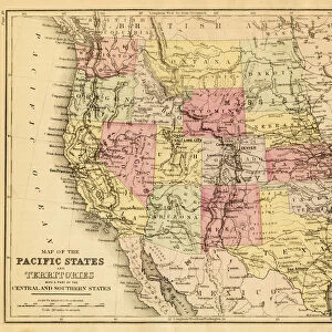
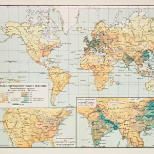
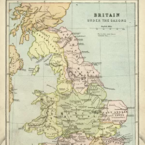
Map of Maryland Virginia North Carolina 1867

![]()
Wall Art and Photo Gifts from Fine Art Storehouse
Map of Maryland Virginia North Carolina 1867
Mitchells Modern Atlas - Published by E.H. Buttler & Co - Philadelphia 1867
Unleash your creativity and transform your space into a visual masterpiece!
THEPALMER
Media ID 13668973
© Roberto A Sanchez
Atlantic Ocean Background Backgrounds Direction Grunge Grunge Image Technique Maryland Maryland State North America North Carolina North Carolina Us State Sepia Toned Virginia Virginia Us State Obsolete
FEATURES IN THESE COLLECTIONS
> Arts
> Artists
> O
> Oceanic Oceanic
> Fine Art Storehouse
> The Magical World of Illustration
> Palmer Illustrated Collection
> Fine Art Storehouse
> Map
> Historical Maps
> Fine Art Storehouse
> Map
> USA Maps
> Maps and Charts
> Related Images
> North America
> Related Images
> North America
> United States of America
> Maps
> North America
> United States of America
> Maryland
> Related Images
> North America
> United States of America
> North Carolina
> Related Images
> North America
> United States of America
> Virginia
> Related Images
EDITORS COMMENTS
This print showcases a vintage map titled "Map of Maryland Virginia North Carolina 1867" from the renowned Mitchells Modern Atlas, published by E. H. Buttler & Co in Philadelphia back in 1867. The image is an engraved masterpiece, highlighting the obsolete art of cartography and providing a glimpse into the physical geography of these three states. The sepia-toned background adds a touch of nostalgia to this piece, transporting us back to a bygone era when maps were meticulously crafted by hand. The intricate details and delicate lines etched on the map depict the boundaries and topographical features with remarkable precision. As we explore this enchanting artwork, our eyes are drawn towards the Atlantic Ocean bordering these states, reminding us of their coastal beauty and historical significance. The grunge image technique employed here lends an air of authenticity to the print, enhancing its vintage charm. With Maryland, Virginia, and North Carolina taking center stage on this map, it serves as both an educational tool for geographical enthusiasts and a stunning visual representation for admirers of old-world craftsmanship. THEPALMER's skillful illustration captures not only the direction but also evokes a sense of adventure that awaits those who embark on exploring these regions. Whether displayed in homes or offices, this horizontal grunge image transports viewers to another time while celebrating America's rich history through its beautifully rendered cartographic artistry.
MADE IN THE USA
Safe Shipping with 30 Day Money Back Guarantee
FREE PERSONALISATION*
We are proud to offer a range of customisation features including Personalised Captions, Color Filters and Picture Zoom Tools
SECURE PAYMENTS
We happily accept a wide range of payment options so you can pay for the things you need in the way that is most convenient for you
* Options may vary by product and licensing agreement. Zoomed Pictures can be adjusted in the Cart.