Home > Fine Art Storehouse > The Magical World of Illustration > Palmer Illustrated Collection
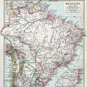
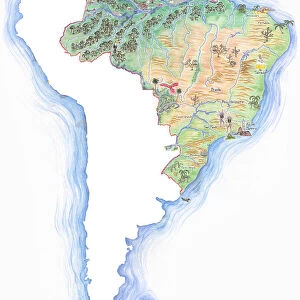
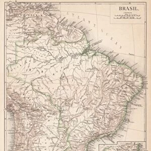
South Brazil map 1895

![]()
Wall Art and Photo Gifts from Fine Art Storehouse
South Brazil map 1895
Meyers Konversations-Lexikon. Ein Nachschlagewerk des allgemeinen Wissens, 5th edition 17 volumes Bibliographisches Institut - Leipzig 1895-1897
Unleash your creativity and transform your space into a visual masterpiece!
THEPALMER
Media ID 13611995
© This content is subject to copyright
Brazil Paper Parana State Sao Paulo South South America World Map Parana Rio Grande Do Sul Sao Paulo State
FEATURES IN THESE COLLECTIONS
> Fine Art Storehouse
> The Magical World of Illustration
> Palmer Illustrated Collection
> Fine Art Storehouse
> Map
> Historical Maps
> Fine Art Storehouse
> Map
> USA Maps
EDITORS COMMENTS
This print showcases a historical gem, the "South Brazil map 1895" sourced from the esteemed Meyers Konversations-Lexikon. With its intricate details and rich colors, this vintage piece takes us back to a bygone era of cartography. The map covers the southern region of Brazil, including states like Parana, Rio Grande do Sul, and Sao Paulo. It offers an intriguing glimpse into South America's physical geography during that time period. The engraving technique used in creating this masterpiece adds a touch of elegance and authenticity to its overall appeal. Printed on aged paper, this antique illustration exudes charm and nostalgia. Its vertical orientation allows for easy display in any space - be it your study room or office wall. Whether you're an avid collector or simply appreciate art with historical significance, this unique find is sure to captivate your imagination. As we gaze upon this remarkable work of art by THEPALMER from Fine Art Storehouse, we are transported back to a time when maps were meticulously hand-drawn and served as gateways to unexplored territories. Let it serve as a reminder of how far we've come in our understanding of the world while appreciating the beauty found within these old-fashioned representations.
MADE IN THE USA
Safe Shipping with 30 Day Money Back Guarantee
FREE PERSONALISATION*
We are proud to offer a range of customisation features including Personalised Captions, Color Filters and Picture Zoom Tools
SECURE PAYMENTS
We happily accept a wide range of payment options so you can pay for the things you need in the way that is most convenient for you
* Options may vary by product and licensing agreement. Zoomed Pictures can be adjusted in the Cart.