Home > Arts > Modern art pieces
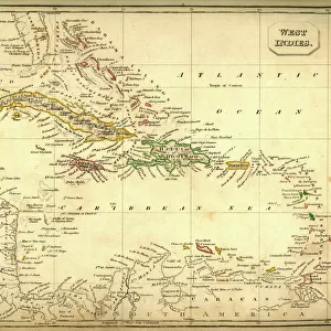
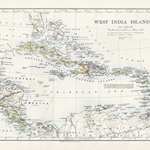
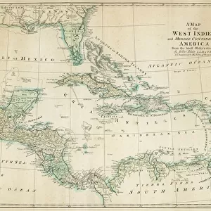
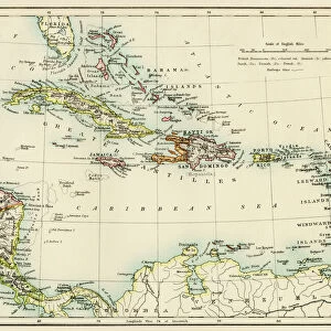
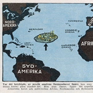
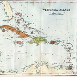
West Indies map 1856

![]()
Wall Art and Photo Gifts from Fine Art Storehouse
West Indies map 1856
Colton and Fitchs Modern School Geography by George W. Fitch - New York 1856
Unleash your creativity and transform your space into a visual masterpiece!
THEPALMER
Media ID 13668785
© Roberto A Sanchez
Antilles Bahamas Barbados Bermuda Caribbean Sea Cuba Florida Us State Florida Usa Gulf Coast States Haiti Island Puerto Rico Textured Effect Trinidad And Tobago West Indies Obsolete
FEATURES IN THESE COLLECTIONS
> Fine Art Storehouse
> The Magical World of Illustration
> Palmer Illustrated Collection
> Fine Art Storehouse
> Map
> Historical Maps
> Fine Art Storehouse
> Map
> USA Maps
> Maps and Charts
> Early Maps
> Maps and Charts
> World
> North America
> The Bahamas
> Maps
> North America
> Barbados
> Maps
> North America
> Bermuda
> Maps
> North America
> Cuba
> Cuba Heritage Sites
> Trinidad and the Valley de los Ingenios
> North America
> Cuba
> Maps
> North America
> Haiti
> Maps
> North America
> Puerto Rico
> Maps
EDITORS COMMENTS
This print showcases a beautifully detailed map of the West Indies from 1856. Taken from Colton and Fitch's Modern School Geography by George W. Fitch, this antique piece of cartography takes us back to a time when engraved images were meticulously crafted by hand. The textured effect on the print adds an extra layer of charm, enhancing the vintage appeal of this old-world treasure. The map encompasses various islands and regions including Trinidad and Tobago, Haiti, Bermuda, Florida USA, Bahamas, Barbados, Puerto Rico, Cuba, and more. As we delve into this engraving's intricate details, we are transported to a time when physical geography was at the forefront of exploration. The West Indies' position in the Caribbean Sea is clearly depicted alongside neighboring countries such as Florida US State and Gulf Coast States. This print not only serves as a visual delight but also acts as a historical artifact that reminds us of how far our understanding of maps has come over the years. It invites us to appreciate both the artistry involved in creating such engravings and their significance in documenting our world's ever-changing landscape. With its horizontal orientation and meticulous illustration style characteristic of its era, this unique piece by THEPALMER is sure to captivate any admirer seeking to add a touch of history to their collection or space.
MADE IN THE USA
Safe Shipping with 30 Day Money Back Guarantee
FREE PERSONALISATION*
We are proud to offer a range of customisation features including Personalised Captions, Color Filters and Picture Zoom Tools
SECURE PAYMENTS
We happily accept a wide range of payment options so you can pay for the things you need in the way that is most convenient for you
* Options may vary by product and licensing agreement. Zoomed Pictures can be adjusted in the Cart.