Home > Arts > Contemporary art > Digital artwork > Street art
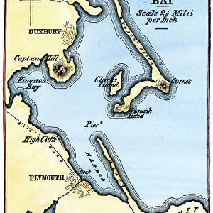
MA Plymouth Duxbury Vector Road Map

![]()
Wall Art and Photo Gifts from Fine Art Storehouse
MA Plymouth Duxbury Vector Road Map
MA Plymouth Duxbury Vector Road Map. All source data is in the public domain. U.S. Census Bureau Census Tiger. Used Layers: areawater, linearwater, roads, rails, cousub, pointlm, uac10
Unleash your creativity and transform your space into a visual masterpiece!
Frank Ramspott
Media ID 20692945
© Frank Ramspott, all rights reserved
City Map Computer Graphic County Digital Composite District Geographical Border Harbor Massachusetts Plymouth Road Map Text Vector Ashdod Digitally Generated Image Duxbury
FEATURES IN THESE COLLECTIONS
> Animals
> Mammals
> Cats (Wild)
> Tiger
> Animals
> Mammals
> Muridae
> Water Mouse
> Arts
> Contemporary art
> Digital artwork
> Street art
> Arts
> Landscape paintings
> Waterfall and river artworks
> River artworks
> Arts
> Portraits
> Pop art gallery
> Street art portraits
> Arts
> Street art graffiti
> Digital art
> Digital paintings
> Fine Art Storehouse
> Map
> Reference Maps
> Maps and Charts
> Related Images
> Popular Themes
> Lake District
EDITORS COMMENTS
This print showcases the MA Plymouth Duxbury Vector Road Map, a stunning piece of cartography art. Designed by Frank Ramspott, this digitally generated image is a testament to his exceptional skills in creating visually appealing and detailed maps. The map encompasses various elements that make it both informative and aesthetically pleasing. It includes layers such as areawater, linearwater, roads, rails, cousub, pointlm, and uac10 sourced from the U. S. Census Bureau Census Tiger database – all of which are in the public domain. In this color image captured through computer graphics and digital composites, you can explore the geographical borders of Massachusetts' Plymouth County district. The city map highlights key features like rivers, lakes (including Tinkertown Lake), water bodies like Ashdod Bay and Harbor Sea. With no people present in the picture itself but an abundance of text denoting street names and other essential details for navigation purposes - this map serves as a valuable tool for locals or tourists exploring the region. Frank Ramspott's mastery shines through in every aspect of this artwork; his attention to detail brings life to each road and landmark depicted on the map. Whether you're fascinated by physical geography or simply appreciate beautiful design work - this vector road map print is sure to captivate your imagination.
MADE IN THE USA
Safe Shipping with 30 Day Money Back Guarantee
FREE PERSONALISATION*
We are proud to offer a range of customisation features including Personalised Captions, Color Filters and Picture Zoom Tools
SECURE PAYMENTS
We happily accept a wide range of payment options so you can pay for the things you need in the way that is most convenient for you
* Options may vary by product and licensing agreement. Zoomed Pictures can be adjusted in the Cart.