Home > Arts > Artists > W > Robert Walker
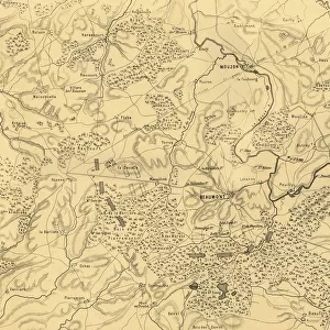
Map of the Battle of Carignan, 30 August 1870, (c1872). Creator: R. Walker
. Creator: R. Walker")
![]()
Wall Art and Photo Gifts from Heritage Images
Map of the Battle of Carignan, 30 August 1870, (c1872). Creator: R. Walker
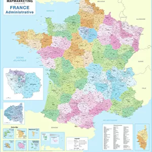
Map of the Battle of Carignan, 30 August 1870, (c1872). Map: Drawn under the Superintendence of Captain Hozier, showing the enemy positions. The Battle of Carignan took place on the same day as the Battle of Beaumont, in northern France. From " The Franco-Prussian War: its causes, incidents and consequences", Volume I, by Captain H M Hozier. [William Mackenzie, London, 1872]
Heritage Images features heritage image collections
Media ID 19778655
© The Print Collector/Heritage Images
1870 1871 Adversary Bamp W Border Enemy Franco Prussian War Front Line Frontier Frontline H M Hozier Henry Montague Henry Montague Hozier Hozier Lines Mackenzie Meuse Prussia Prussian Prussian Army R Walker River Maas River Meuse Robert Walker Sir Henry Montagu Hozier Walker William Mackenzie Battlefield Carignan
FEATURES IN THESE COLLECTIONS
> Arts
> Artists
> W
> Robert Walker
> Europe
> France
> Canton
> Meuse
> Europe
> United Kingdom
> England
> London
> Related Images
EDITORS COMMENTS
This print showcases a historical map titled "Map of the Battle of Carignan, 30 August 1870". Created by R. Walker in approximately 1872, this map was drawn under the supervision of Captain Hozier to depict enemy positions during the battle. The Battle of Carignan occurred on the same day as the Battle of Beaumont in northern France. The map provides a detailed overview of the river, lines, country borders, and geographical features surrounding Carignan. It offers valuable insights into warfare strategies employed by both French and Prussian armies during this significant conflict. As a representation of military history from the late 19th century, it serves as an important resource for understanding armed forces' movements and tactics. This print transports viewers back to a time when nations clashed on European soil. Its monochromatic aesthetic adds an air of nostalgia while highlighting crucial details that would have guided commanders on both sides. The intricate lines and symbols denote frontlines, rivers such as Meuse (also known as Maas), and other key elements essential for comprehending battlefield dynamics. With its rich historical significance captured through Robert Walker's skilled craftsmanship, this print is not only visually appealing but also holds immense educational value for those interested in studying conflicts like the Franco-Prussian War. Preserved within Captain H M Hozier's comprehensive account published in Volume I of "The Franco-Prussian War: its causes, incidents and consequences" this artifact stands testament to human endeavors amidst adversity.
MADE IN THE USA
Safe Shipping with 30 Day Money Back Guarantee
FREE PERSONALISATION*
We are proud to offer a range of customisation features including Personalised Captions, Color Filters and Picture Zoom Tools
SECURE PAYMENTS
We happily accept a wide range of payment options so you can pay for the things you need in the way that is most convenient for you
* Options may vary by product and licensing agreement. Zoomed Pictures can be adjusted in the Cart.