Home > Europe > United Kingdom > England > London > Art > Theatre
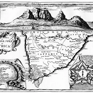
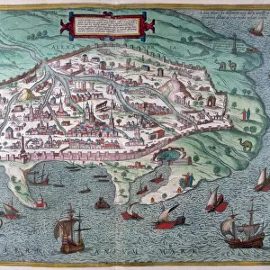
New England in 1660, (c1880)
")
![]()
Wall Art and Photo Gifts from Heritage Images
New England in 1660, (c1880)
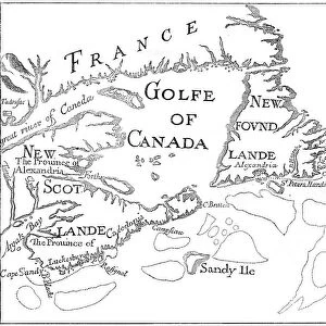
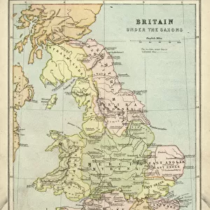
New England in 1660, (c1880). From Blaeus Theatre du Monde. In this curious map the north is at the bottom and the south at the top. A print from Cassells History of the United States, by Edmund Ollier, Volume I, Cassell Petter and Galpin, London, c1880
Heritage Images features heritage image collections
Media ID 14946159
© The Print Collector / Heritage-Images
Blaeu Cartography Colonisation Colony Deer Edmund Edmund Ollier Joan Joan Blaeu Johann Blaeu Johannes Blaeu Map Making New England Ollier Print Collector8
FEATURES IN THESE COLLECTIONS
> Arts
> Artists
> B
> Joan Blaeu
> Europe
> United Kingdom
> England
> London
> Art
> Theatre
> Europe
> United Kingdom
> England
> Maps
> North America
> United States of America
> Maps
EDITORS COMMENTS
This print takes us back in time to New England in 1660, as depicted by the renowned cartographer Joan Blaeu. The unique aspect of this map lies in its orientation, with the north positioned at the bottom and the south at the top, challenging our perception of direction. A product of meticulous engraving and monochrome artistry, this historical piece offers a glimpse into the early days of colonisation in America. The intricate details on this map showcase not only geographical features but also elements that define life during that era. Amongst rolling hills and winding rivers, we can spot various animals roaming freely across New England's vast wilderness. A majestic deer stands out amidst its surroundings, symbolizing both nature's abundance and man's harmonious coexistence with it. As we delve further into this image, it becomes evident that every line drawn represents more than just land boundaries; they embody stories of exploration and discovery. This print is a testament to the tireless efforts made by individuals like Edmund Ollier to document America's rich history. Preserved through time, this black-and-white masterpiece serves as a reminder of how far our nation has come since those early colonial days. It invites us to reflect upon our roots while appreciating the progress made over centuries. As we gaze upon this remarkable work from The Print Collector collection, let us be inspired by those who came before us and continue building upon their legacy for generations to come.
MADE IN THE USA
Safe Shipping with 30 Day Money Back Guarantee
FREE PERSONALISATION*
We are proud to offer a range of customisation features including Personalised Captions, Color Filters and Picture Zoom Tools
SECURE PAYMENTS
We happily accept a wide range of payment options so you can pay for the things you need in the way that is most convenient for you
* Options may vary by product and licensing agreement. Zoomed Pictures can be adjusted in the Cart.