Home > Europe > United Kingdom > England > London > Transport > Stations
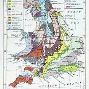
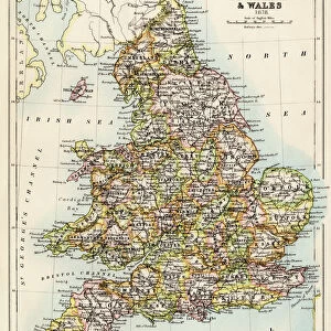
Railway Map of England and Wales, 1902. Creator: Unknown

![]()
Wall Art and Photo Gifts from Heritage Images
Railway Map of England and Wales, 1902. Creator: Unknown
Railway Map of England and Wales, 1902. With inset showing stations in London. From The Century Atlas of the World. [John Walker & Co, Ltd. London, 1902]
Heritage Images features heritage image collections
Media ID 15512558
© The Print Collector / Heritage-Images
British Isles Edinburgh Geographical Institute Network Wales
FEATURES IN THESE COLLECTIONS
> Europe
> United Kingdom
> England
> London
> Transport
> Railway
> Europe
> United Kingdom
> England
> London
> Transport
> Stations
> Europe
> United Kingdom
> England
> Maps
> Europe
> United Kingdom
> England
> Railways
> Europe
> United Kingdom
> Scotland
> Edinburgh
> Edinburgh
> Europe
> United Kingdom
> Scotland
> Lothian
> Edinburgh
> Europe
> United Kingdom
> Wales
> Maps
> Europe
> United Kingdom
> Wales
> Posters
> Europe
> United Kingdom
> Wales
> Railways
> Maps and Charts
> Related Images
EDITORS COMMENTS
This print showcases a Railway Map of England and Wales from the year 1902. With its intricate details and vibrant colors, it offers a glimpse into the extensive railway network that connected these two nations over a century ago. The creator of this remarkable piece remains unknown, adding an air of mystery to its historical significance. The map features an inset showing the various stations in London, highlighting the capital city's crucial role as a transportation hub during that era. Published in The Century Atlas of the World by John Walker & Co. , Ltd. , London, this print is not only visually stunning but also provides valuable insights into Britain's transport infrastructure at the turn of the 20th century. Crafted by Edinburgh Geographical Institute, this map exemplifies their commitment to accuracy and precision in cartography. It serves as a testament to their expertise in depicting geographical information with utmost clarity. Transportation enthusiasts and history buffs alike will appreciate this print for its ability to transport them back in time. As we gaze upon this vintage masterpiece, we are reminded of how railways revolutionized travel and trade during Britain's industrialization period. Preserved by The Print Collector, this image captures an important chapter in British history when rail networks were expanding rapidly across England and Wales. Its enduring charm makes it a cherished artifact that continues to inspire awe even today.
MADE IN THE USA
Safe Shipping with 30 Day Money Back Guarantee
FREE PERSONALISATION*
We are proud to offer a range of customisation features including Personalised Captions, Color Filters and Picture Zoom Tools
SECURE PAYMENTS
We happily accept a wide range of payment options so you can pay for the things you need in the way that is most convenient for you
* Options may vary by product and licensing agreement. Zoomed Pictures can be adjusted in the Cart.