Home > Europe > United Kingdom > Maps
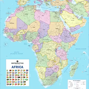
1818, Pinkerton Map of Africa, John Pinkerton, 1758 - 1826, Scottish antiquarian

![]()
Wall Art and Photo Gifts from Liszt Collection
1818, Pinkerton Map of Africa, John Pinkerton, 1758 - 1826, Scottish antiquarian
1818, Pinkerton Map of Africa, John Pinkerton, 1758 - 1826, Scottish antiquarian, cartographer, UK
Liszt Collection of nineteenth-century engravings and images to browse and enjoy
Media ID 14007010
© Artokoloro Quint Lox Limited
1758 1826 1758 – 1826 17581826 1818 Cartographer John Pinkerton Scottish Antiquarian Antique Map Atlas Chart Geographic Latitude Longitude Mappa Mundi Old Antique Plan Old Antique View Old Map Ols Antique Map Rare Old Maps Topo
FEATURES IN THESE COLLECTIONS
> Africa
> Related Images
> Europe
> United Kingdom
> Maps
> Maps and Charts
> Early Maps
> Maps and Charts
> World
EDITORS COMMENTS
This print showcases the remarkable "1818, Pinkerton Map of Africa" created by John Pinkerton, a renowned Scottish antiquarian and cartographer. With meticulous attention to detail, Pinkerton skillfully crafted this map, which serves as a testament to his expertise in geography and topography. The map's intricate design features a grid system of latitude and longitude lines that beautifully intersect with geometric precision. Its vintage aesthetic adds an air of nostalgia, taking us back to a time when exploration and discovery were at the forefront of human endeavors. As we delve into this historical artifact, we are transported to an era where paper maps held immense value in navigating the uncharted territories of Africa. The ancient artistry displayed on this decorative piece not only provides insight into African regions but also offers glimpses into the world as it was during Pinkerton's time. This rare gem from the Liszt Collection invites us on a journey through history, allowing us to appreciate both its artistic beauty and its significance as an invaluable tool for early explorers. Whether you're an avid collector or simply fascinated by old maps, this antique treasure is sure to captivate your imagination with its rich historical context and timeless allure.
MADE IN THE USA
Safe Shipping with 30 Day Money Back Guarantee
FREE PERSONALISATION*
We are proud to offer a range of customisation features including Personalised Captions, Color Filters and Picture Zoom Tools
SECURE PAYMENTS
We happily accept a wide range of payment options so you can pay for the things you need in the way that is most convenient for you
* Options may vary by product and licensing agreement. Zoomed Pictures can be adjusted in the Cart.