Home > Europe > France > Heritage Sites > The Loire Valley between
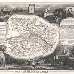
1852, Levasseur Map of the Department De La Haute Loire, France, Loire Valley Region

![]()
Wall Art and Photo Gifts from Liszt Collection
1852, Levasseur Map of the Department De La Haute Loire, France, Loire Valley Region
Liszt Collection of nineteenth-century engravings and images to browse and enjoy
Media ID 14005251
© Artokoloro Quint Lox Limited
1852 Antique Map Atlas Chart Geographic Latitude Longitude Mappa Mundi Old Antique Plan Old Antique View Old Map Ols Antique Map Rare Old Maps Topo
FEATURES IN THESE COLLECTIONS
> Europe
> France
> Canton
> Loire
> Europe
> France
> Heritage Sites
> The Loire Valley between
> Maps and Charts
> Early Maps
> Maps and Charts
> World
EDITORS COMMENTS
This print showcases the intricate details of the 1852 Levasseur Map of the Department De La Haute Loire in France's enchanting Loire Valley region. A true masterpiece of cartography, this vintage map offers a glimpse into a bygone era, where exploration and discovery were at the forefront of geographical understanding. The topography is meticulously depicted, with every contour and elevation carefully illustrated. The chart's grid lines reveal precise latitude and longitude coordinates, allowing for accurate navigation across this picturesque landscape. Its geometric design adds an artistic touch to its informative purpose. As we delve into history through this ancient map, we are transported back in time to witness the rich heritage and cultural significance of this region. The paper itself exudes an aged charm that further enhances its historical value. With its decorative elements and attention to detail, this rare old map serves as both a visual delight and a valuable educational resource. It invites us on a journey through time, inviting us to explore not only physical landscapes but also the stories embedded within them. Whether you are an avid traveler or simply appreciate artistry intertwined with geography, this Levasseur Map print from Liszt Collection is sure to captivate your imagination and spark curiosity about our world's past.
MADE IN THE USA
Safe Shipping with 30 Day Money Back Guarantee
FREE PERSONALISATION*
We are proud to offer a range of customisation features including Personalised Captions, Color Filters and Picture Zoom Tools
SECURE PAYMENTS
We happily accept a wide range of payment options so you can pay for the things you need in the way that is most convenient for you
* Options may vary by product and licensing agreement. Zoomed Pictures can be adjusted in the Cart.