Home > Europe > France > Paris > Maps
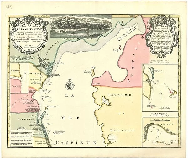
Map Carte marine de la Mer Caspiene levA e suivant les ordres de S. M
![]()

Wall Art and Photo Gifts from Liszt Collection
Map Carte marine de la Mer Caspiene levA e suivant les ordres de S. M
Map, Carte marine de la Mer Caspiene levee suivant les ordres de S.M. czariene, par Mr. Carl Vanverden en 1719, 1720, et 1721, et reduite au meridien de Paris par Guillaume Delisle premier geographe du Roy... Guillaume Delisle (1675-1726), Carl Vanverden, Copperplate print
Liszt Collection of nineteenth-century engravings and images to browse and enjoy
Media ID 19585209
© Artokoloro
1675 1726 1720 Copperplate Print Guillaume Delisle
EDITORS COMMENTS
This print showcases a remarkable map titled "Carte marine de la Mer Caspiene levée suivant les ordres de S. M". Created by the talented Mr. Carl Vanverden between 1719 and 1721, this exquisite piece of cartography was later reduced to the meridian of Paris by the renowned geographer Guillaume Delisle, who served as the first geographer to the King. The map itself is a testament to both artistic skill and scientific precision. Crafted using copperplate printing techniques, it exudes an air of elegance that transports viewers back in time to an era when exploration and discovery were at their peak. As we delve into its intricate details, we are transported across vast oceans and along distant coastlines, tracing our fingers over each contour line and imagining the adventures that took place upon these waters centuries ago. The Caspian Sea unfolds before us like a hidden treasure waiting to be explored. Guillaume Delisle's expertise shines through in his meticulous attention to accuracy, ensuring that this maritime chart serves not only as a work of art but also as a valuable navigational tool for sailors navigating these treacherous waters. This print from Liszt Collection allows us to appreciate the beauty and historical significance of this extraordinary map while paying homage to two brilliant minds who contributed greatly to our understanding of geography - Guillaume Delisle and Carl Vanverden.
MADE IN THE USA
Safe Shipping with 30 Day Money Back Guarantee
FREE PERSONALISATION*
We are proud to offer a range of customisation features including Personalised Captions, Color Filters and Picture Zoom Tools
SECURE PAYMENTS
We happily accept a wide range of payment options so you can pay for the things you need in the way that is most convenient for you
* Options may vary by product and licensing agreement. Zoomed Pictures can be adjusted in the Cart.

