Home > Arts > Artists > G > Charles Green
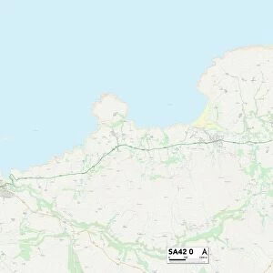
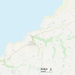
Cornwall PL26 8 Map

![]()
Wall Art and Photo Gifts from Map Marketing
Cornwall PL26 8 Map
Postcode Sector Map of Cornwall PL26 8
Media ID 19978320
Arundel Close Ashley Close Bassett Close Bodmin Road Bowling Green Chapel Road Charles Street Church Road Churchill Way Cornwall Crescent Road Douglas Close Downs Close Dukes Court Eden Way Fore Street Foxglove Close Glebe Drive Hall Road Hermitage Road Horseshoe Close Kent Close Maple Close Marshall Close Mayfield Drive Meadow Rise Montgomery Road Mountbatten Road New Street Old Lane Orchard Park Park Lane Pine View Primrose Close Queens Close Rectory Road Red Lane Springfield Way Springfields St Michaels Way Station Road Tedder Road The Meadows The Sidings The Willows Thornton Close Tor View Victoria Road Warren Court Wellington Road Wesley Close Whitegate Windy Ridge Wood Close Bilberry Bugle Roche St Dennis Trengove
FEATURES IN THESE COLLECTIONS
> Arts
> Artists
> G
> Charles Green
> Europe
> United Kingdom
> England
> Cornwall
> Angarrack
> Europe
> United Kingdom
> England
> Cornwall
> Bodmin
> Europe
> United Kingdom
> England
> Cornwall
> Bugle
> Europe
> United Kingdom
> England
> Cornwall
> Carne
> Europe
> United Kingdom
> England
> Cornwall
> Carthew
> Europe
> United Kingdom
> England
> Cornwall
> Chapel Town
> Europe
> United Kingdom
> England
> Cornwall
> Edgcumbe
> Europe
> United Kingdom
> England
> Cornwall
> Lockengate
> Europe
> United Kingdom
> England
> Cornwall
> Penhale
> Map Marketing
> Postcode Sector Maps
> PL - Plymouth
> Map Marketing
> UK Maps
MADE IN THE USA
Safe Shipping with 30 Day Money Back Guarantee
FREE PERSONALISATION*
We are proud to offer a range of customisation features including Personalised Captions, Color Filters and Picture Zoom Tools
SECURE PAYMENTS
We happily accept a wide range of payment options so you can pay for the things you need in the way that is most convenient for you
* Options may vary by product and licensing agreement. Zoomed Pictures can be adjusted in the Cart.