Home > Europe > Italy > Sicily > Messina
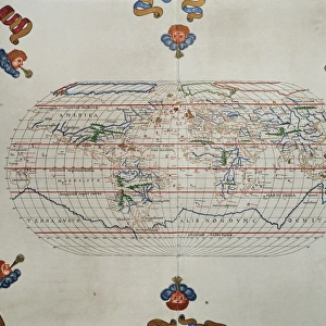
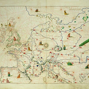
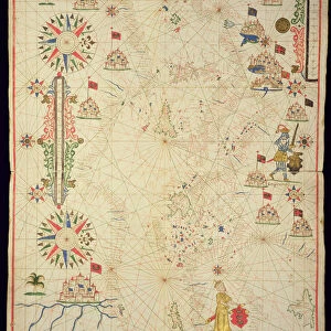
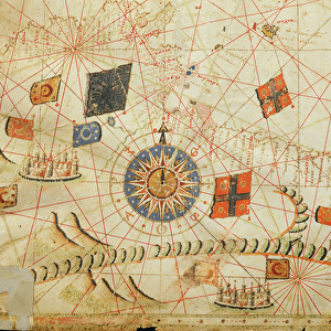
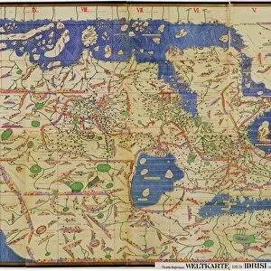
Portolan atlas by Joan Martines (1556-1590). Western
. Western")
![]()
Wall Art and Photo Gifts from Mary Evans Picture Library
Portolan atlas by Joan Martines (1556-1590). Western
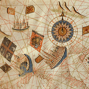
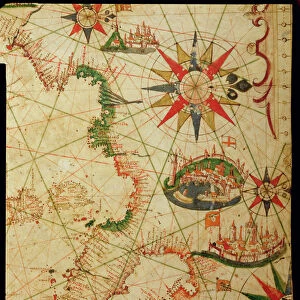
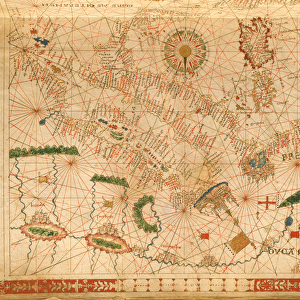
Portolan atlas of the world by Joan Martines (1556-1590). Messina, 1587. Western Mediterranean. National Library. Madrid. Spain
Mary Evans Picture Library makes available wonderful images created for people to enjoy over the centuries
Media ID 14406606
© Thaliastock / Mary Evans
1587 Area Atlas Balearic Biblioteca Cartography Chart Colours Continent Element Geography Illuminated Nacional Cartographical Cosmographer
FEATURES IN THESE COLLECTIONS
> Africa
> Related Images
> Animals
> Mammals
> Muridae
> Western Mediterranean Mouse
> Animals
> Mammals
> Muridae
> Western Mouse
> Europe
> Italy
> Related Images
> Europe
> Italy
> Sicily
> Messina
> Europe
> Spain
> Related Images
EDITORS COMMENTS
This stunning image showcases a page from the Portolan Atlas created by Joan Martines in Messina, Sicily, in 1587. Dated to the late 16th century, this atlas is a testament to the rich cartographical knowledge of the time. The intricately detailed map depicts the Western Mediterranean, with a focus on the African coast and the Balearic Islands. The vibrant colors and decorative elements add an artistic touch to the informative chart, making it not only a valuable resource for geographical knowledge but also a beautiful work of art. Joan Martines, a cosmographer, painstakingly illustrated each map in the atlas with meticulous attention to detail. The map is adorned with decorative elements, including elaborate borders and colorful illustrations of cities and coastal towns. The use of color adds depth and dimension to the map, making it easier to distinguish between different regions and bodies of water. The map highlights the Western Mediterranean, with the African continent extending to the bottom of the page. The intricate detailing of the African coastline reveals the extensive exploration and knowledge of the region during this period. The Balearic Islands, located in the western Mediterranean, are also prominently featured, with their individual islands clearly marked. This Portolan Atlas is a significant historical artifact, providing valuable insights into the geographical knowledge of the late 16th century. Its intricate detailing and decorative elements make it a beautiful work of art, showcasing the intersection of cartography and art during this period. The map is currently housed in the Biblioteca Nacional de España in Madrid, Spain, where it continues to inspire and intrigue scholars and visitors alike.
MADE IN THE USA
Safe Shipping with 30 Day Money Back Guarantee
FREE PERSONALISATION*
We are proud to offer a range of customisation features including Personalised Captions, Color Filters and Picture Zoom Tools
SECURE PAYMENTS
We happily accept a wide range of payment options so you can pay for the things you need in the way that is most convenient for you
* Options may vary by product and licensing agreement. Zoomed Pictures can be adjusted in the Cart.