Home > Arts > Artists > K > Johannes van Keulen
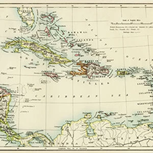
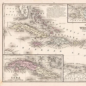
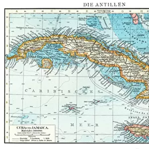
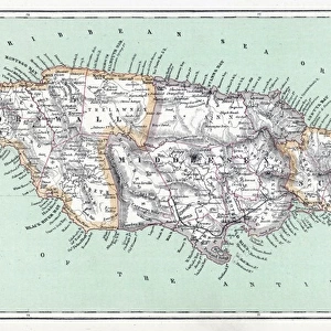
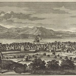
Sea chart of the south coast of Cuba and Jamaica, Jan Luyken, Claes Jansz Voogt

![]()
Wall Art and Photo Gifts from Liszt Collection
Sea chart of the south coast of Cuba and Jamaica, Jan Luyken, Claes Jansz Voogt
Sea chart of the south coast of Cuba and Jamaica, Jan Luyken, Claes Jansz Voogt, Johannes van Keulen (I), 1684 - 1799
Liszt Collection of nineteenth-century engravings and images to browse and enjoy
Media ID 12716211
© Quint Lox Limited
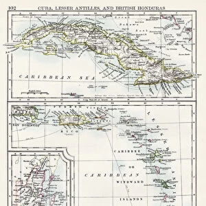
1684 1799 Address Archers Weapons Arrows Bays Beasts Prey Betting Bow Arrow Bows Cards Claes Jansz Voogt Coast Compass Compass Roses Cuba Dark Feathers French Miles Jamaica Jan Luyken Johannes Van Keulen Leopard North Panther Predatory Animals Roses Scale Sea Chart Snake Snakes South South Coast Chart Roars Tamed
FEATURES IN THESE COLLECTIONS
> Animals
> Insects
> Hemiptera
> Rose Scale
> Animals
> Mammals
> Cats (Wild)
> Leopard
> Arts
> Artists
> K
> Johannes van Keulen
> Arts
> Artists
> L
> Jan Luyken
> Maps and Charts
> World
> North America
> Cuba
> Maps
> North America
> Jamaica
> Maps
EDITORS COMMENTS
This print showcases a remarkable sea chart of the south coast of Cuba and Jamaica, created by renowned cartographers Jan Luyken, Claes Jansz Voogt, and Johannes van Keulen. Dating back to the late 17th century, this map offers a fascinating glimpse into the world of geographical exploration during that era. The intricate details depicted on this chart are truly awe-inspiring. From the archers' weapons with their bows and arrows to the predatory animals such as panthers and snakes lurking in the wilderness, every element tells a story of adventure and danger. The presence of betting cards suggests that even in those times, human indulgences were not far behind. Amidst this wild landscape stands a dark man adorned with feathers, skillfully taming a leopard while its wild counterpart roars nearby. This juxtaposition between civilization and untamed nature is both intriguing and symbolic. As we explore further into this sea chart's depths, compass roses guide us along our journey while French miles mark our progress. Each bay holds its own secrets waiting to be discovered. Quint Lox has masterfully captured this historical piece from the Liszt Collection through his lens. Through his photography skills, he allows us to appreciate not only the artistry but also the significance of these ancient maps in shaping our understanding of past civilizations and their relationship with geography.
MADE IN THE USA
Safe Shipping with 30 Day Money Back Guarantee
FREE PERSONALISATION*
We are proud to offer a range of customisation features including Personalised Captions, Color Filters and Picture Zoom Tools
SECURE PAYMENTS
We happily accept a wide range of payment options so you can pay for the things you need in the way that is most convenient for you
* Options may vary by product and licensing agreement. Zoomed Pictures can be adjusted in the Cart.