Home > Sheffield City Archives > Maps and Plans > Sheffield OS maps
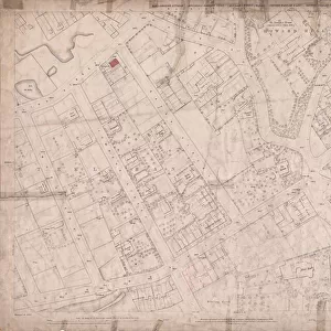
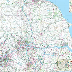
Ordnance Survey Map, Sheffield, Cornish Street area, Netherthorpe, Sheffield, 1889 (Yorkshire sheet 294. 7. 5)
")
![]()
Wall Art and Photo Gifts from Sheffield City Archives
Ordnance Survey Map, Sheffield, Cornish Street area, Netherthorpe, Sheffield, 1889 (Yorkshire sheet 294. 7. 5)
This map features:
Top left: Bedford Street, Burys and Co. Ltd. steel manufacturers, Regent Works, Penistone Road and Philadelphia Steel Works, Penistone Road / Bedford Street, Penistone Road, Dixon Street, Engineering Works, River Don, Artisan Street, Waterloo Walk, Rock File Works, Don Inn, [Joseph Wostenholm and Son, razors, table bowie and scalp knife manufacturer], Perseverance Works, Penistone Road, Smithy, File Works, Neepsend Rolling Mills [Neepsend Rolling Mills Ltd], Samuel Osborn and Co. Limited, Rutland Works, Rutland Road, St. Marys Works, Cornish Street, Neepsend Lane, Bacon Island.
Top right: River Don, Neepsend Lane, Ball Street, [John Bedford and Sons], Lion Works, Mowbray Street, [Taylor Brothers, manufacturers of saws, steel, files, machine knives, ] Adelaide Works, Mowbray Street, [Joseph Pickering and Sons Ltd. furniture polish manufacturers], Albyn Works, Burton Road, [? Possibly Turton Brothers and Matthew] Neepsend Spring Works, Neepsend Rolling Mill [Neepsend Rolling Mills Ltd], Burton Road, [George Longden and Son, manufacturers of ground gannister], Neepsend Gannister Mill, Neepsend Lane, Hicks Street, Percy Street, Lancaster Street, Mowbray Street, St. Michaels and All Angels Church, Corporation Yard, Converting Works, Engineering Works, Smithy, Royal Oak Public House, Malton Hotel Public House, Norfolk Hotel Public House, [John Swinscoe, timber merchant], Norfolk Saw Mills, Mowbray Street, Timber Yard.
Bottom left: Penistone Road, Dixon Street, [? Theaker Engineering Co. engineers and stem hammer makers], Engineering Works, Cornish Street, St. Philips Church, Church Yard, [George Barnsley and Sons, merchants and manufactures of steel files, edge tools, etc], Cornish Works, Cornish Steet, [Wright, Bindley and Gell Ltd. steel, tools and wire manufacturers] North British Steel Works, Penistone Road, Cornish Street, Montgomery Terrace Road, Infirmary Road, Tramway, St. Philips Terrace, Montgomery House, St. Philips Road, St. Philips Lane, Lister Lane, Henry Street, [A. H. Smith and Co. Brewers] Don Brewery, Penistone Road, [? John Lucas and Sons Ltd. or Steel and Garland Ltd.] Wharncliffe Works, Cornish Street, Green Lane, Royal Lancers Public House, Watery Street, Moray Place.
Bottom right: River Don, Cornish Street, [A. H. Smith and Co. Brewers] Don Brewery, Penistone Road, [? John Lucas and Sons Ltd. or Steel and Garland Ltd.] Wharncliffe Works, Cornish Street, Green Lane, Ball Street, [John Bedford and Sons], Lion Works, Ball Street, [Taylor Brothers, manufacturers of saws, steel, files, machine knives, ] Adelaide Works, Lancaster Street, Timber Yard, [? Thackray William Henry, and Sons, engineers], Ball Bridge Works, Ball Street, Ball Bridge, Ball Street, Cornish Place, Cornish Inn, Ball Inn, [Alfred Beckett and Sons Ltd. steel manufacturers], Brooklyn Works, Green Lane, [? Moulson Brothers], South Yorkshire Steel Works, Green Lane, Mill Dam, Timber Yard, [Henry Hoole and Co. manufacturers of stove grates, fenders, etc.] Green Lane Works, Andrew Badger and Sons, [Ironfounders] Long Croft Works, Green Lane, [Wheatman and Smith, Steel Converters and Refiners], Russell Works [Kelham Island].
Dimensions of original: 77 x 102 cm.
Scale 10.56 feet : 1 mile [1:500].
From an original at Sheffield Libraries: q00050 (sheet No. 294.7.5)
Sheffield City Archives and Local Studies Library has an unrivalled collection of images of Sheffield, England
Media ID 24576213
© Sheffield City Council - All Rights Reserved
Netherthorpe Old Map Os Map Sheffield Yorkshire
EDITORS COMMENTS
This print showcases an Ordnance Survey Map of the Cornish Street area in Netherthorpe, Sheffield, dating back to 1889. The detailed map, known as Yorkshire sheet 294.7.5, offers a fascinating glimpse into the city's industrial landscape during that era. The top left section of the map reveals bustling streets such as Bedford Street and Dixon Street, lined with various steel manufacturers like Burys and Co. Ltd. , Regent Works, and Philadelphia Steel Works. Notably featured is Joseph Wostenholm and Son, renowned for their razor production. Moving to the top right corner of the map, we encounter Neepsend Lane alongside River Don. This area boasts notable establishments including Lion Works by John Bedford and Sons, Taylor Brothers' Adelaide Works specializing in saws and machine knives manufacturing, as well as Joseph Pickering and Sons Ltd. , famous for their furniture polish production at Mowbray Street's Albyn Works. The bottom left section highlights Penistone Road with its engineering works while featuring George Barnsley and Sons' Cornish Works on Cornish Street - a prominent manufacturer of steel files and edge tools at that time. Lastly, exploring the bottom right portion unveils more industrial landmarks such as A. H. Smith & Co. 's Don Brewery on Cornish Street along with Wharncliffe Works nearby. Ball Bridge Works by Alfred Beckett & Sons Ltd. , Brooklyn Works owned by Moulson Brothers are also depicted here. Measuring approximately 77 x 102 cm in dimensions with a scale ratio of 10.56 feet:1 mile (1:500), this historical gem from Sheffield Libraries provides invaluable insights into Sheffield's past urban development.
MADE IN THE USA
Safe Shipping with 30 Day Money Back Guarantee
FREE PERSONALISATION*
We are proud to offer a range of customisation features including Personalised Captions, Color Filters and Picture Zoom Tools
SECURE PAYMENTS
We happily accept a wide range of payment options so you can pay for the things you need in the way that is most convenient for you
* Options may vary by product and licensing agreement. Zoomed Pictures can be adjusted in the Cart.