Home > Europe > United Kingdom > England > West Sussex > Chichester
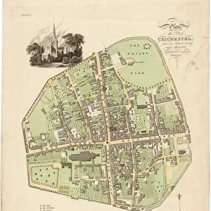
Chichester St. Peter the Great [Subdeanery] tithe map, 1846-1847
![Chichester St. Peter the Great [Subdeanery] tithe map, 1846-1847](/p/479/chichester-st-peter-great-subdeanery-tithe-10701869.jpg.webp "Chichester St. Peter the Great [Subdeanery] tithe map, 1846-1847")
![]()
Wall Art and Photo Gifts from West Sussex County Council
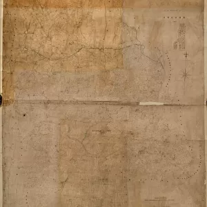
Chichester St. Peter the Great [Subdeanery] tithe map, 1846-1847
Map of the District comprising so much of the Parish of St. Peter the Great otherwise Subdeanery as is without the Walls of the City of Chichester. By Joseph Butler. 26.6 in. to 1 m. 71 × 60
Tithe Award Map Collection
West Sussex Record Office Ref No: TD/W29
West Sussex County Council Record Office contains a fascinating history of the county of West Sussex, England
Media ID 10701869
© West Sussex County Council - All Rights Reserved
FEATURES IN THESE COLLECTIONS
> Europe
> United Kingdom
> England
> Sussex
> Chichester
> Europe
> United Kingdom
> England
> Sussex
> Related Images
> Europe
> United Kingdom
> England
> West Sussex
> Chichester
> Europe
> United Kingdom
> England
> West Sussex
> Related Images
> Maps and Charts
> Early Maps
> Maps and Charts
> Related Images
> West Sussex County Council
> West Sussex Record Office
> Tithe Award Maps, 1808-1859
EDITORS COMMENTS
This print showcases the Chichester St. Peter the Great [Subdeanery] tithe map, dating back to 1846-1847. The map, created by Joseph Butler, provides a detailed representation of the district encompassing a significant portion of the Parish of St. Peter the Great outside the walls of Chichester city. Measuring at an impressive scale of 26.6 inches to 1 mile and spanning across an area measuring approximately 71 by 60 miles, this historical mapping artifact offers valuable insights into land ownership and usage during the mid-19th century. Part of the renowned Tithe Award Map Collection held at West Sussex Record Office, this print is a testament to our rich heritage and serves as a vital resource for researchers and history enthusiasts alike. It is important to note that this image should not be associated with any commercial use or reference to any specific company. Instead, it stands as a remarkable piece documenting our local history and cultural landscape. With its intricate details and meticulous craftsmanship, this photograph invites us on a journey through time, allowing us to explore how Chichester's outskirts were organized in terms of land divisions over one hundred years ago.
MADE IN THE USA
Safe Shipping with 30 Day Money Back Guarantee
FREE PERSONALISATION*
We are proud to offer a range of customisation features including Personalised Captions, Color Filters and Picture Zoom Tools
SECURE PAYMENTS
We happily accept a wide range of payment options so you can pay for the things you need in the way that is most convenient for you
* Options may vary by product and licensing agreement. Zoomed Pictures can be adjusted in the Cart.