Home > Europe > United Kingdom > England > London > Art > Theatre
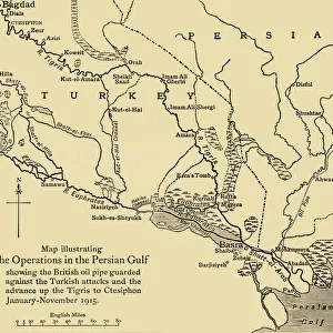
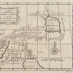
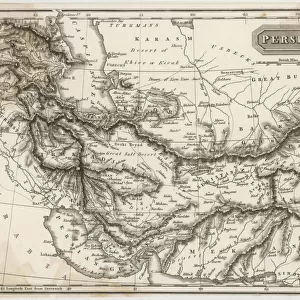
Map illustrating the Operations in the Persian Gulf, First World War, 1915, (c1920)
")
![]()
Wall Art and Photo Gifts from Heritage Images
Map illustrating the Operations in the Persian Gulf, First World War, 1915, (c1920)
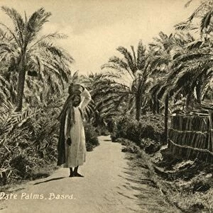
Map illustrating the Operations in the Persian Gulf, First World War, 1915, (c1920)....showing the British oil pipe guarded against the Turkish attacks and the advance up the Tigris to Amara, January - June 1915. From " The Great World War - A History" Volume III, edited by Frank A Mumby. [The Gresham Publishing Company Ltd, London, c1920]
Heritage Images features heritage image collections
Media ID 19175459
© The Print Collector/Heritage Images
Basra Euphrates Frank Arthur Frank Arthur Mumby Gresham Publishing Co Ltd Gresham Publishing Company Iran Iraq Keystone Archives Mumby Mumby Frank Arthur Oil Industry Persia Persian Gulf Persian Gulf Asia Pipeline River Euphrates River Tigris The Great World War A History Theatre Of War Tigris Tigris River Turkey Turkish Oil Pipeline
FEATURES IN THESE COLLECTIONS
> Asia
> Iran
> Related Images
> Asia
> Iraq
> Related Images
> Asia
> Turkey
> Related Images
> Europe
> United Kingdom
> England
> London
> Art
> Theatre
> Historic
> World War I and II
> World War I
> Historic
> World War I and II
> Maps and Charts
> Related Images
EDITORS COMMENTS
This print captures a significant moment in history - the operations in the Persian Gulf during World War I. Taken from "The Great World War - A History". Volume III, edited by Frank A Mumby, this map illustrates the British oil pipe guarded against Turkish attacks and their advance up the Tigris to Amara between January and June 1915. The image showcases the strategic importance of the region as it highlights key geographical features such as Basra, Euphrates River, Fertile Crescent, Iran, Iraq, Persia, Persian Gulf, Tigris River, and Turkey. The map also emphasizes how vital oil was even during that time period with its depiction of an oil pipeline running through the area. It is fascinating to see how this map served as a tool for military planning and decision-making during one of history's most significant conflicts. The intricate details on display provide insight into the complexities faced by both British forces guarding their valuable oil infrastructure and Turkish troops attempting to disrupt their operations. This print serves as a reminder of the immense challenges faced by nations involved in World War I across various theaters of war. It represents not only a historical document but also an artifact that symbolizes human ingenuity amidst conflict.
MADE IN THE USA
Safe Shipping with 30 Day Money Back Guarantee
FREE PERSONALISATION*
We are proud to offer a range of customisation features including Personalised Captions, Color Filters and Picture Zoom Tools
SECURE PAYMENTS
We happily accept a wide range of payment options so you can pay for the things you need in the way that is most convenient for you
* Options may vary by product and licensing agreement. Zoomed Pictures can be adjusted in the Cart.