Home > Europe > France > Canton > Landes
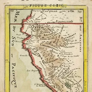
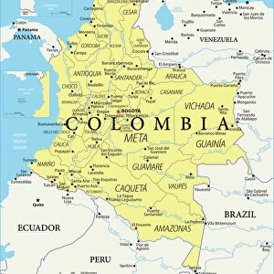
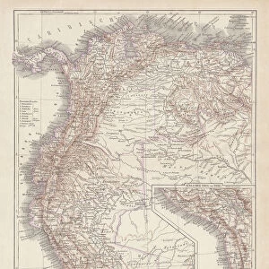
Peru, Ecuador, Colombia, Venezuela, lithograph, published in 1877

![]()
Wall Art and Photo Gifts from Fine Art Storehouse
Peru, Ecuador, Colombia, Venezuela, lithograph, published in 1877
Ancient map of Peru, Ecuador, Colombia, and Venezuela. Lithograph, published in 1877
Unleash your creativity and transform your space into a visual masterpiece!
Media ID 13666767
© ZU_09
Colombia Contour Drawing Country Geographic Area Ecuador Fax Machine Land Peru South America The Americas Topographic Map Topography Venezuela World Map Colombian Culture
FEATURES IN THESE COLLECTIONS
> Europe
> France
> Canton
> Landes
> Fine Art Storehouse
> Map
> Historical Maps
> Maps and Charts
> Early Maps
> Maps and Charts
> Related Images
> Maps and Charts
> World
> South America
> Colombia
> Maps
> South America
> Colombia
> Related Images
> South America
> Ecuador
> Maps
> South America
> Ecuador
> Related Images
> South America
> Peru
> Maps
EDITORS COMMENTS
This lithograph, published in 1877, takes us on a journey through the rich history and topography of Peru, Ecuador, Colombia, and Venezuela. The ancient map showcases the intricate details of these South American countries with its engraved images and contour drawings. As we gaze upon this antique print, we are transported back in time to an era when cartography was both a science and an art form. The vertical composition allows us to explore the vast landscapes that make up these nations - from the majestic Andes Mountains to the sprawling Amazon rainforest. The meticulous craftsmanship of this lithograph reveals not only the geographical features but also provides insights into cultural aspects. It offers glimpses into Colombian traditions and Peruvian heritage while highlighting Ecuadorian landmarks. This historical document serves as a testament to the diverse tapestry of cultures that have shaped this region over centuries. Despite being created over a century ago, this image continues to captivate viewers today. Its timeless appeal lies in its ability to transport us across borders and connect us with our shared human history. Whether displayed in homes or educational institutions, it serves as a reminder of how maps can bridge gaps between generations by preserving knowledge for future exploration.
MADE IN THE USA
Safe Shipping with 30 Day Money Back Guarantee
FREE PERSONALISATION*
We are proud to offer a range of customisation features including Personalised Captions, Color Filters and Picture Zoom Tools
SECURE PAYMENTS
We happily accept a wide range of payment options so you can pay for the things you need in the way that is most convenient for you
* Options may vary by product and licensing agreement. Zoomed Pictures can be adjusted in the Cart.