Home > Arts > Artists > R > Roman Roman
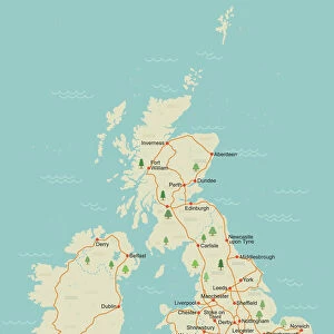
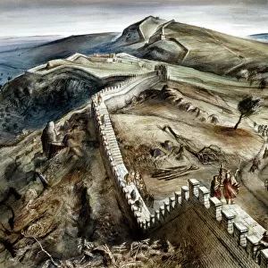
Celtic and Roman Britain, 1926. Creator: Emery Walker Ltd

![]()
Wall Art and Photo Gifts from Heritage Images
Celtic and Roman Britain, 1926. Creator: Emery Walker Ltd
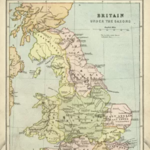
Celtic and Roman Britain, 1926. Map of Britain during the Roman (43 to 410 AD) and Celtic periods. All the forts and towns here marked had roads to them, even in the Welsh mountains. The forts along the coast from Brancaster to Portsmouth were naval bases against the Saxon pirates. Far the greatest part of the land, high and low, must be conceived as under forest or scrub, and the river valleys water-logged. From " History of England", by George Macaulay Trevelyan. [Longmans, Green and Co. Ltd, London, 1926]
Heritage Images features heritage image collections
Media ID 19044892
© The Print Collector/Heritage Images
Boutall Cartography Celtic Coastline Cockerell Emery Emery Walker Limited Emery Walker Ltd Fort Forts Green And Co Hadrians Wall History Of England Longman Longman And Co Longmans Map Making Network Occupied Territory Roads Roberts And Green Roman Britain Roman Empire Trevelyan Wales Walker Walker And Walker And Boutall Walker And Cockerell
FEATURES IN THESE COLLECTIONS
> Arts
> Artists
> R
> Roman Roman
> Arts
> Artists
> W
> Robert Walker
> Arts
> Landscape paintings
> Forest and woodland scenes
> Forest artwork
> Arts
> Literature
> Europe
> France
> Canton
> Landes
> Europe
> Italy
> Lazio
> Rome
> Europe
> United Kingdom
> England
> Maps
> Europe
> United Kingdom
> England
> Portsmouth
EDITORS COMMENTS
This print showcases a detailed map of Celtic and Roman Britain during the years 43 to 410 AD. Created by Emery Walker Ltd, this historical artifact provides a visual representation of the ancient forts, towns, and roads that once dotted the landscape. Even in the rugged Welsh mountains, roads connected these settlements, highlighting the advanced infrastructure of the time. The coastal forts from Brancaster to Portsmouth served as crucial naval bases for defense against Saxon pirates who threatened Britain's shores. As described in George Macaulay Trevelyan's "History of England" published by Longmans, Green and Co. Ltd in London in 1926, vast stretches of land were covered with dense forests or scrub vegetation while river valleys remained water-logged. This remarkable piece offers insights into both cartography and history. It reflects an era when Roman occupation shaped Britain's geography and culture significantly. The intricate details captured within this print allow viewers to immerse themselves in a world where Roman influence intertwined with Celtic heritage. Emery Walker Limited expertly preserved this snapshot from our past through their artistry and dedication to historical accuracy. By examining this map closely, one can gain a deeper understanding of how ancient civilizations navigated and occupied territories across what is now modern-day England and Wales.
MADE IN THE USA
Safe Shipping with 30 Day Money Back Guarantee
FREE PERSONALISATION*
We are proud to offer a range of customisation features including Personalised Captions, Color Filters and Picture Zoom Tools
SECURE PAYMENTS
We happily accept a wide range of payment options so you can pay for the things you need in the way that is most convenient for you
* Options may vary by product and licensing agreement. Zoomed Pictures can be adjusted in the Cart.