Road Communications in Afghanistan

![]()
Wall Art and Photo Gifts from Mary Evans Picture Library
Road Communications in Afghanistan
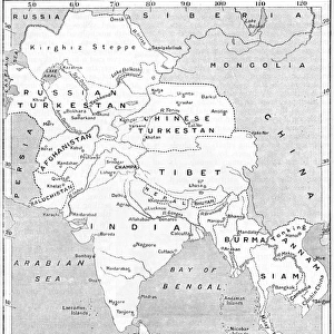
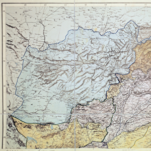
Road Communications in Afghanistan. Sketch No 1. Map showing details of railways, roads and telegraph lines. Published by General Staff, India, February 1939. From a collection of papers associated with Col Alexander Stalker Lancaster, 10th Gurkha Rifles, 1917-1956, relating principally to his tours of duty as Military Attache in Kabul, 1934-1935 and 1940-1948. Date: 1939
Mary Evans Picture Library makes available wonderful images created for people to enjoy over the centuries
Media ID 14404182
© The National Army Museum / Mary Evans Picture Library
10th 1956 Afghanistan Alexander Details Gurkha Lancaster Lines Papers Railways Rifles Roads Staff Stalker Telegraph
EDITORS COMMENTS
This intriguing map, titled "Road Communications in Afghanistan. Sketch No 1," is a fascinating glimpse into the transportation infrastructure of Afghanistan during the late 1930s. Published by the General Staff in India in February 1939, this map provides a detailed overview of the railways, roads, and telegraph lines that connected various parts of the country. The map is part of a larger collection of papers associated with Colonel Alexander Stalker Lancaster, a British military officer who served as Military Attaché in Kabul from 1934 to 1935 and again from 1940 to 1948. The map reveals a complex network of transportation routes that crisscrossed Afghanistan, with several major railways and roads shown running through the country. The railways, represented by solid red lines, include the Kabul-Jalalabad line and the Herat-Kandahar line, both of which were significant arteries for the movement of goods and people. The roads, denoted by dashed lines, are equally extensive, connecting major cities and towns throughout the country. Telegraph lines, represented by thin blue lines, are also shown on the map, indicating the importance of communication networks in the region. The map's meticulous detail and clear labeling make it an invaluable resource for understanding the transportation infrastructure of Afghanistan during this period. The map's historical significance is further underscored by its association with Colonel Lancaster, who played a key role in British military operations in Afghanistan during the early to mid-20th century. Overall, this map offers a captivating glimpse into the transportation history of Afghanistan and the broader geopolitical context of the region during a pivotal time in world history.
MADE IN THE USA
Safe Shipping with 30 Day Money Back Guarantee
FREE PERSONALISATION*
We are proud to offer a range of customisation features including Personalised Captions, Color Filters and Picture Zoom Tools
SECURE PAYMENTS
We happily accept a wide range of payment options so you can pay for the things you need in the way that is most convenient for you
* Options may vary by product and licensing agreement. Zoomed Pictures can be adjusted in the Cart.