Home > Arts > Street art graffiti > Digital art > Vector illustrations
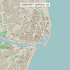
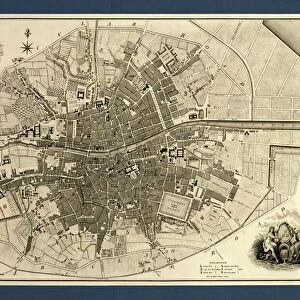
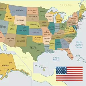
Watertown South Dakota US City Street Map

![]()
Wall Art and Photo Gifts from Fine Art Storehouse
Watertown South Dakota US City Street Map
Vector Illustration of a City Street Map of Watertown, South Dakota, USA. Scale 1:60, 000.
All source data is in the public domain.
U.S. Geological Survey, US Topo
Used Layers:
USGS The National Map: National Hydrography Dataset (NHD)
USGS The National Map: National Transportation Dataset (NTD)
Unleash your creativity and transform your space into a visual masterpiece!
Frank Ramspott
Media ID 15215800
© Frank Ramspott, all rights reserved
Aerial View City Map Computer Graphic Directly Above Downtown District Gray Road Map South Dakota Text Digitally Generated Image Green Color Watertown White Color
FEATURES IN THESE COLLECTIONS
> Aerial Photography
> Related Images
> Animals
> Insects
> Hemiptera
> Green Scale
> Arts
> Contemporary art
> Digital artwork
> Street art
> Arts
> Landscape paintings
> Waterfall and river artworks
> River artworks
> Arts
> Portraits
> Pop art gallery
> Street art portraits
> Arts
> Street art graffiti
> Digital art
> Digital paintings
> Arts
> Street art graffiti
> Digital art
> Vector illustrations
> Fine Art Storehouse
> Map
> Street Maps
> Fine Art Storehouse
> Map
> USA Maps
> Maps and Charts
> Geological Map
> Maps and Charts
> Related Images
> North America
> United States of America
> Lakes
> Related Images
EDITORS COMMENTS
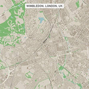
This print showcases a meticulously detailed city street map of Watertown, South Dakota, USA. With a scale of 1:60,000, every intricate feature is brought to life in this vector illustration. The artist has skillfully utilized various layers from the USGS National Map including the National Hydrography Dataset and National Transportation Dataset to create an accurate representation of the city. The image captures the essence of Watertown's downtown district with its bustling streets and vibrant atmosphere. A beautiful lake and river can be seen flowing through the heart of the city, adding to its charm. The roads are clearly marked, allowing viewers to navigate through every corner effortlessly. Rendered in shades of gray, blue, white, and green colors against a backdrop of textural elements gives this digitally generated image a unique aesthetic appeal. Its aerial perspective provides a bird's-eye view directly above Watertown, offering an unparalleled glimpse into its physical geography. This stunning piece by Frank Ramspott is not only visually striking but also serves as an invaluable resource for cartography enthusiasts or anyone seeking to explore Watertown's urban landscape. With no people present in the image itself, it allows viewers to focus solely on appreciating the artistry behind this masterful creation.
MADE IN THE USA
Safe Shipping with 30 Day Money Back Guarantee
FREE PERSONALISATION*
We are proud to offer a range of customisation features including Personalised Captions, Color Filters and Picture Zoom Tools
SECURE PAYMENTS
We happily accept a wide range of payment options so you can pay for the things you need in the way that is most convenient for you
* Options may vary by product and licensing agreement. Zoomed Pictures can be adjusted in the Cart.