Home > Maps and Charts > Geological Map
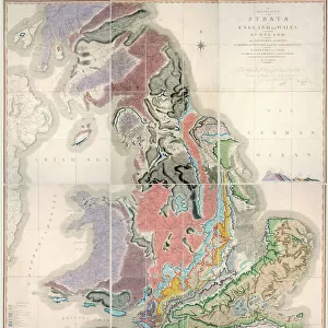
1907, Geological Survey Map of San Francisco Peninsula after 1906 Earthquake, topography

![]()
Wall Art and Photo Gifts from Liszt Collection
1907, Geological Survey Map of San Francisco Peninsula after 1906 Earthquake, topography
1907, Geological Survey Map of San Francisco Peninsula after 1906 Earthquake
Liszt Collection of nineteenth-century engravings and images to browse and enjoy
Media ID 14008137
© Artokoloro Quint Lox Limited
1907 Antique Map Atlas Chart Geographic Latitude Longitude Mappa Mundi Old Antique Plan Old Antique View Old Map Ols Antique Map Rare Old Maps Topo
FEATURES IN THESE COLLECTIONS
> Maps and Charts
> Early Maps
> Maps and Charts
> Geological Map
> Maps and Charts
> World
EDITORS COMMENTS
This print showcases the remarkable 1907 Geological Survey Map of San Francisco Peninsula after the devastating 1906 earthquake. With its intricate topography, this map provides a detailed visual representation of the land's transformation following one of the most catastrophic natural disasters in American history. The artistry and precision evident in this cartographic masterpiece are truly awe-inspiring. Every contour, grid line, latitude, and longitude has been meticulously depicted to accurately portray the geography of this region. This vintage piece exudes an air of antiquity and historical significance that transports us back to a bygone era. As we gaze upon this aged treasure, we cannot help but marvel at its decorative nature. The delicate illustrations and earthy color palette add a touch of artistic flair to an otherwise scientific document. It serves as both a navigational tool for exploration and a work of art that captures our imagination. Through this rare old map, we embark on a journey through time and space, discovering not only the geographical features but also delving into the rich history embedded within these ancient lines. It is indeed fascinating how such maps were once vital instruments for understanding our world. This print from Liszt Collection offers us an opportunity to appreciate the beauty inherent in historical cartography while honoring those who painstakingly created it over a century ago. Let it serve as a reminder of humanity's resilience in face of adversity and our continuous quest for knowledge about our planet's ever-changing landscapes.
MADE IN THE USA
Safe Shipping with 30 Day Money Back Guarantee
FREE PERSONALISATION*
We are proud to offer a range of customisation features including Personalised Captions, Color Filters and Picture Zoom Tools
SECURE PAYMENTS
We happily accept a wide range of payment options so you can pay for the things you need in the way that is most convenient for you
* Options may vary by product and licensing agreement. Zoomed Pictures can be adjusted in the Cart.