Home > Europe > United Kingdom > Wales > Gwent > Newport
Derby DE24 0 Map

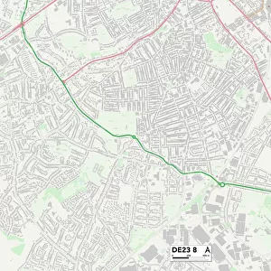
![]()
Wall Art and Photo Gifts from Map Marketing
Derby DE24 0 Map
Postcode Sector Map of Derby DE24 0
Media ID 19969553
Appian Way Arlington Drive Barrett Street Beech Avenue Beech Gardens Berwick Close Blandford Close Branksome Avenue Caroline Close Chapman Avenue Church Street Compton Close Cornmill Close Coronation Avenue Coronation Crescent Dale Road Derby Dovedale Avenue Edale Avenue Falmouth Road Farm Drive Field Drive Field Lane Field View Close Frederick Avenue Gilbert Street Glastonbury Road Goodwood Drive Grange Road Harlow Close Harvey Road Hatfield Road Haven Court Haywood Close Heathcote Close Helston Close Holbrook Road Holloway Road Humber Close Launceston Road Lilac Close Maple Drive Matthew Street Medina Close Metcalfe Close Mill Hill Moor Drive Oak Drive Orchard Close Padstow Road Pendennis Close Pool Close Poplar Close Rochester Close Rosedale Avenue Rosemary Drive Rosewood Close Sandalwood Close Sidmouth Close St Marys Close St Michaels Close Stanley Road Strathmore Avenue Sweetbriar Close Taunton Close The Court The Crescent The Greenway The Lees The Paddock Walnut Avenue Wesley Road Wyndham Street Yew Tree Close Boulton
FEATURES IN THESE COLLECTIONS
> Arts
> Artists
> C
> Frederick Church
> Europe
> United Kingdom
> Wales
> Gwent
> Newport
> Europe
> United Kingdom
> Wales
> Pembrokeshire
> Newport
> Map Marketing
> Postcode Sector Maps
> DE - Derby
> Maps and Charts
> Related Images
MADE IN THE USA
Safe Shipping with 30 Day Money Back Guarantee
FREE PERSONALISATION*
We are proud to offer a range of customisation features including Personalised Captions, Color Filters and Picture Zoom Tools
SECURE PAYMENTS
We happily accept a wide range of payment options so you can pay for the things you need in the way that is most convenient for you
* Options may vary by product and licensing agreement. Zoomed Pictures can be adjusted in the Cart.