Home > Asia > China > Maps
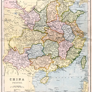
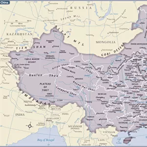
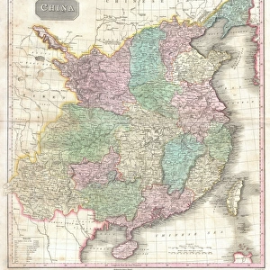
Map of China (engraving)
")
![]()
Wall Art and Photo Gifts from Fine Art Finder
Map of China (engraving)
1619580 Map of China (engraving) by English School, (19th century); Private Collection; (add.info.: Map of China. Illustration for The Illustrated London News, 24 July 1858.
English School (19th Century)); Look and Learn / Illustrated Papers Collection
Media ID 22556140
© Look and Learn / Illustrated Papers Collection / Bridgeman Images
FEATURES IN THESE COLLECTIONS
> Arts
> Artists
> Related Images
> Fine Art Finder
> Artists
> English School
> Maps and Charts
> Related Images
EDITORS COMMENTS
This print showcases a remarkable piece of history - an engraving titled "Map of China" created by the English School in the 19th century. The intricate details and precision of this map are truly awe-inspiring, providing us with a glimpse into the past. The map, originally published as an illustration for The Illustrated London News on July 24,1858, offers valuable insights into the geography and boundaries of China during that era. It serves as a testament to the importance placed on cartography in documenting and understanding our world. As we examine this vintage artwork, we can't help but marvel at its significance. It reminds us of how maps have played a crucial role in shaping our perception of different cultures and regions throughout history. In particular, it sheds light on China's rich heritage and vast territory. The inclusion of this print within private collections speaks to its enduring appeal among art enthusiasts who appreciate both its aesthetic value and historical significance. Its presence allows viewers to connect with a time long gone while also appreciating the skillful craftsmanship behind its creation. Whether you are fascinated by Chinese culture or simply intrigued by antique maps, this engraving is sure to captivate your imagination. Let it transport you back in time as you explore the intricacies of ancient China through this beautifully preserved piece from Bridgeman Images' Fine Art Finder collection.
MADE IN THE USA
Safe Shipping with 30 Day Money Back Guarantee
FREE PERSONALISATION*
We are proud to offer a range of customisation features including Personalised Captions, Color Filters and Picture Zoom Tools
SECURE PAYMENTS
We happily accept a wide range of payment options so you can pay for the things you need in the way that is most convenient for you
* Options may vary by product and licensing agreement. Zoomed Pictures can be adjusted in the Cart.