Home > Arts > Artists > T > John Tallis
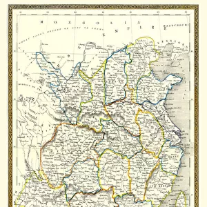
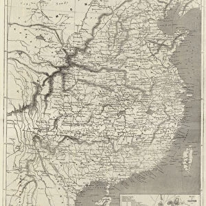
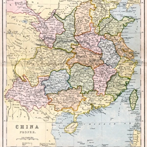
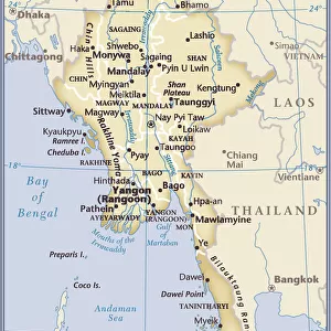
China & Burma 1851

![]()
Wall Art and Photo Gifts from MapSeeker
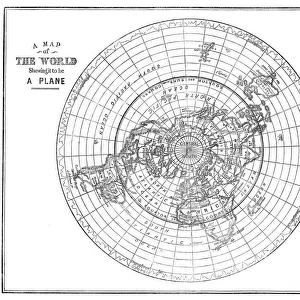
China & Burma 1851
A fine facimile artworked from an antique original map of China and Burma, issued as part of the 1851 edition of John Tallis and Companys " The Illustrated Atlas and Modern History of the World"
Welcome to the Mapseeker Image library and enter an historic gateway to one of the largest on-line collections of Historic Maps, Nostalgic Views, Vista's and Panorama's from a World gone by.
Media ID 20347658
© Mapseeker Publishing Ltd
John Tallis John Tallis Map Tallis Map
FEATURES IN THESE COLLECTIONS
> Arts
> Artists
> T
> John Tallis
> Asia
> Myanmar
> Related Images
> Maps and Charts
> Related Images
> Maps and Charts
> World
> MapSeeker
> Maps of Asia and Middle East
EDITORS COMMENTS
This print showcases a remarkable piece of history - a fine facsimile artworked from an antique original map of China and Burma, dating back to 1851. The map was originally issued as part of the prestigious 1851 edition of John Tallis and Company's "The Illustrated Atlas and Modern History of the World". With intricate details and exquisite craftsmanship, this old map offers a glimpse into the past, transporting us to a bygone era when cartography was both an art form and a means for exploration. It depicts not only China but also Burma (now known as Myanmar), providing valuable insights into the geography and boundaries of these ancient lands. John Tallis, renowned for his expertise in producing high-quality maps during the 19th century, collaborated with talented artist John Rapkin to create this masterpiece. Their combined efforts resulted in an aesthetically pleasing representation that captures the essence of these regions. As we admire this photo print, we are reminded of how far we have come in terms of geographical knowledge while appreciating the dedication and skill required to produce such detailed works centuries ago. This visual treasure serves as a testament to our fascination with history and our desire to preserve it through beautiful reproductions like this one.
MADE IN THE USA
Safe Shipping with 30 Day Money Back Guarantee
FREE PERSONALISATION*
We are proud to offer a range of customisation features including Personalised Captions, Color Filters and Picture Zoom Tools
SECURE PAYMENTS
We happily accept a wide range of payment options so you can pay for the things you need in the way that is most convenient for you
* Options may vary by product and licensing agreement. Zoomed Pictures can be adjusted in the Cart.