Home > Asia > China > Maps
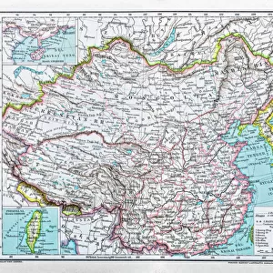
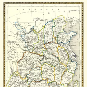
Map / Asia / China C1880

![]()
Wall Art and Photo Gifts from Mary Evans Picture Library
Map / Asia / China C1880
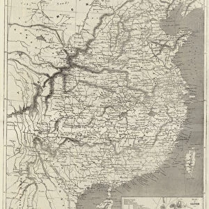
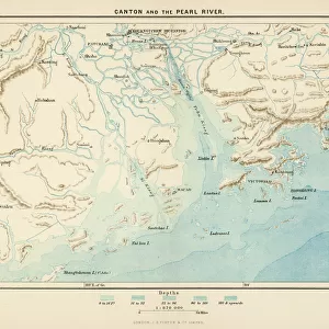
China Proper showing the individual provinces, and underlining names of ports open to foreign trade Date: circa 1880
Mary Evans Picture Library makes available wonderful images created for people to enjoy over the centuries
Media ID 14260100
© Mary Evans Picture Library
C1880 Foreign Individual Maps Names Ports Proper Provinces
FEATURES IN THESE COLLECTIONS
> Maps and Charts
> Early Maps
EDITORS COMMENTS
This map print, dating back to circa 1880, offers a glimpse into the political and economic landscape of China during the late Qing Dynasty. Titled "China Proper," the map meticulously outlines the individual provinces of China, each labeled in English and Chinese characters. The map's primary focus, however, is the underlined names of the ports open to foreign trade, which were crucial nodes of interaction between China and the Western world during this period. The map provides a fascinating window into China's complex history, as the country was undergoing significant transformations in the late 19th century. The Opium Wars (1839-1842 and 1856-1860) had forced China to open its ports to foreign trade, leading to increased interaction between Chinese and Western cultures. The map reflects this new reality, with major ports such as Shanghai, Guangzhou, and Xiamen prominently marked. The map's intricate detailing and accurate representation of the geography of China during this time make it an essential historical document. It provides valuable insights into the political and economic landscape of China during the late Qing Dynasty, a period of significant change and interaction with the Western world. The map's underlining of the open ports also highlights the importance of maritime trade in shaping China's relationship with the outside world. Overall, this map print is an invaluable resource for anyone interested in the history of China and its interactions with the world during the late 19th century.
MADE IN THE USA
Safe Shipping with 30 Day Money Back Guarantee
FREE PERSONALISATION*
We are proud to offer a range of customisation features including Personalised Captions, Color Filters and Picture Zoom Tools
SECURE PAYMENTS
We happily accept a wide range of payment options so you can pay for the things you need in the way that is most convenient for you
* Options may vary by product and licensing agreement. Zoomed Pictures can be adjusted in the Cart.