Home > Aerial Photography > Related Images
Psg25 Technique for Vertical Or Plan Mapping Aerial Phot?

![]()
Wall Art and Photo Gifts from Mary Evans Picture Library
Psg25 Technique for Vertical Or Plan Mapping Aerial Phot?
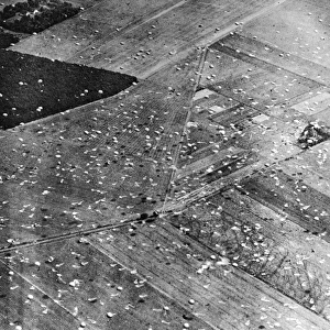
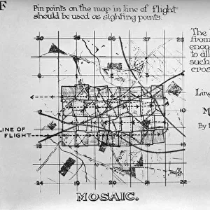
Psg25 Technique for Vertical Or Plan Mapping Aerial Photography to Avoid Bad Results - Straight and Level Or Banking - Early Years of Aerial-Photography History - Instructions Date: 1910s
Mary Evans Picture Library makes available wonderful images created for people to enjoy over the centuries
Media ID 18412862
© aviation-images.com / Mary Evans Picture Library
Air To Ground Archive Days Histories Olden Past Rafaerial
FEATURES IN THESE COLLECTIONS
> Aerial Photography
> Related Images
> Mary Evans Prints Online
> Aviation Images
EDITORS COMMENTS
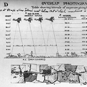
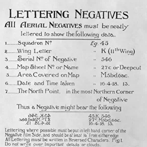
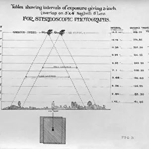
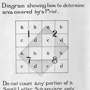
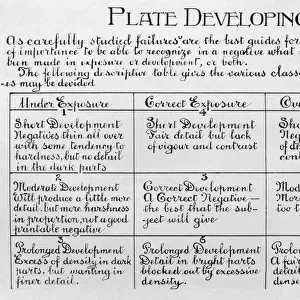
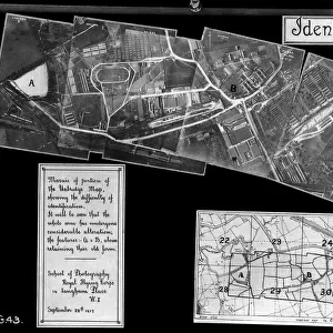
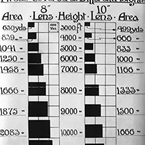
1. Title: Psg25 Technique for Vertical or Plan Mapping Aerial Photography: Ensuring Accurate Results in the Early Years of Aerial Imaging (1910s) 2.. In the early years of aerial photography, particularly during the 1910s, capturing accurate and reliable images from the sky was a significant challenge. One technique that emerged to address this issue was the Psg25 Technique, which was essential for vertical or plan mapping aerial photography. This method ensured that aerial images were taken with the camera parallel to the ground, thereby reducing distortion and ensuring more accurate representations of the terrain below. The Royal Air Force (RAF) in the United Kingdom was a pioneer in the use of aerial photography for military purposes during this era. The Psg25 Technique was a crucial development for the RAF's mapping and reconnaissance efforts, as it allowed for more precise and reliable data collection. To execute the Psg25 Technique, the pilot would maintain a steady and level flight path, keeping the aircraft's wings level and the camera aligned directly with the ground. Alternatively, the pilot could bank the aircraft slightly to one side, ensuring that the camera remained perpendicular to the ground, capturing a plan view of the terrain. This archival photograph, dating back to the 1910s, showcases the early days of aerial photography and the importance of techniques like the Psg25 Technique in achieving accurate and reliable results. The image serves as a reminder of the historical significance of aerial imaging and its role in shaping our understanding of the world around us. Mary Evans Prints Online is proud to offer this vintage, rights-managed photograph as a testament to the rich history of aerial photography and its evolution over the decades. This image is not to be used for commercial purposes and is intended for historical, educational, or research purposes only.
MADE IN THE USA
Safe Shipping with 30 Day Money Back Guarantee
FREE PERSONALISATION*
We are proud to offer a range of customisation features including Personalised Captions, Color Filters and Picture Zoom Tools
FREE COLORIZATION SERVICE
You can choose advanced AI Colorization for this picture at no extra charge!
SECURE PAYMENTS
We happily accept a wide range of payment options so you can pay for the things you need in the way that is most convenient for you
* Options may vary by product and licensing agreement. Zoomed Pictures can be adjusted in the Cart.