Home > Aerial Photography > Related Images
Psg28 Instructions for Technique of Overlap Mapping Aeri?

![]()
Wall Art and Photo Gifts from Mary Evans Picture Library
Psg28 Instructions for Technique of Overlap Mapping Aeri?
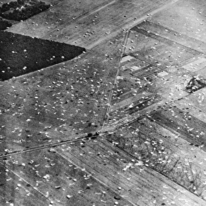
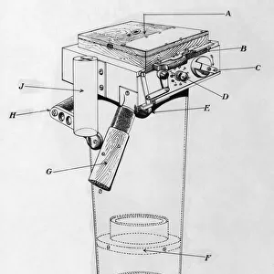
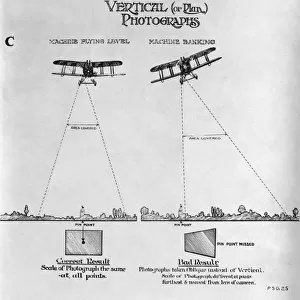
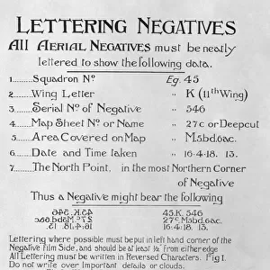
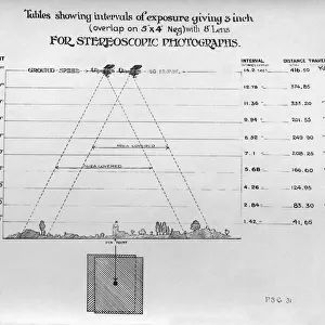
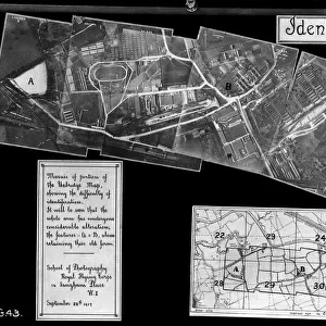
Psg28 Instructions for Technique of Overlap Mapping Aerial Photographs - Early Years of Aerial-Photography History - Instructions Date: 1910s
Mary Evans Picture Library makes available wonderful images created for people to enjoy over the centuries
Media ID 18412864
© aviation-images.com / Mary Evans Picture Library
Air To Ground Archive Days Histories Olden Past Rafaerial
FEATURES IN THESE COLLECTIONS
> Aerial Photography
> Related Images
> Mary Evans Prints Online
> Aviation Images
EDITORS COMMENTS
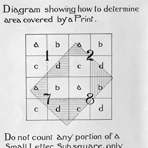
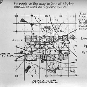
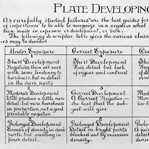
1. Title: "Psg28 Instructions for Technique of Overlap Mapping Aerial Photographs: A Glimpse into the Early Years of Aerial Photography History (1910s)" 2.. This vintage print showcases a page from a manual titled "Psg28: Instructions for Technique of Overlap Mapping Aerial Photographs," offering a fascinating peek into the early history of aerial photography. Dating back to the 1910s, this document was likely used by pioneering aviators and surveyors in the United Kingdom, who employed aerial photography for various purposes, including topographic mapping and military reconnaissance. The Royal Air Force (RAF) and the Royal Flying Corps (RFC) were among the earliest adopters of aerial photography during this period. The use of aerial views from an altitude provided a unique perspective, enabling the creation of detailed maps and the identification of ground features that were otherwise difficult to access or observe from the ground. The instructions on this page outline the technique of overlap mapping, a crucial process for creating accurate and detailed aerial surveys. Overlap mapping involves taking multiple photographs of the same area from slightly different angles to ensure that there is some overlap between the images. This overlap allows for the creation of a three-dimensional representation of the terrain, which can then be used to create accurate maps or orthophotos. The historical significance of aerial photography during this era is evident in the meticulous instructions provided in this manual. The use of aerial photography revolutionized various industries, including cartography, agriculture, and military intelligence, and paved the way for the advancements in aerial imaging technology that we see today. This print is an invaluable archival resource, offering a captivating glimpse into the past and the early days of aerial photography history.
MADE IN THE USA
Safe Shipping with 30 Day Money Back Guarantee
FREE PERSONALISATION*
We are proud to offer a range of customisation features including Personalised Captions, Color Filters and Picture Zoom Tools
FREE COLORIZATION SERVICE
You can choose advanced AI Colorization for this picture at no extra charge!
SECURE PAYMENTS
We happily accept a wide range of payment options so you can pay for the things you need in the way that is most convenient for you
* Options may vary by product and licensing agreement. Zoomed Pictures can be adjusted in the Cart.