Home > Aerial Photography > Related Images
Psg43 Lesson on Identification and Labelling of Vertical?

![]()
Wall Art and Photo Gifts from Mary Evans Picture Library
Psg43 Lesson on Identification and Labelling of Vertical?
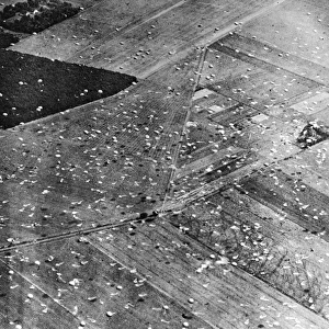
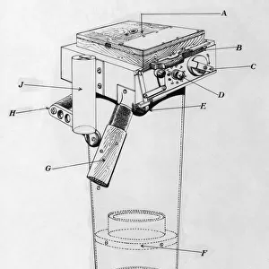
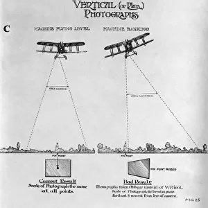
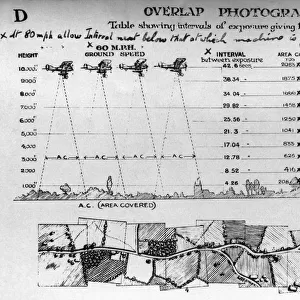
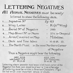
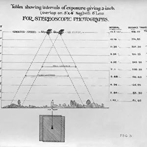
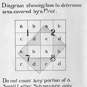
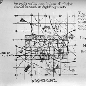
Psg43 Lesson on Identification and Labelling of Vertical Aerial Photography and Mapping Pictures Using Uxbridge As an Example - Early Years of Aerial-Photography History - Instructions, Equipment and Pictures Date: 1910s
Mary Evans Picture Library makes available wonderful images created for people to enjoy over the centuries
Media ID 18412924
© aviation-images.com / Mary Evans Picture Library
Air To Ground Archive Days Histories Olden Past Rafaerial
FEATURES IN THESE COLLECTIONS
> Aerial Photography
> Related Images
> Mary Evans Prints Online
> Aviation Images
EDITORS COMMENTS
Step into the past and discover the fascinating world of early aerial photography and mapping with this image from the 1910s, featuring a PSG43 lesson on identification and labelling of vertical aerial photography and mapping pictures using Uxbridge as an example. During this era, the Royal Flying Corps (RFC), the precursor to the Royal Air Force (RAF), was at the forefront of aerial photography innovation. This photograph offers a unique glimpse into the early days of aerial-view technology, showcasing the equipment and instructions used to capture and interpret vertical aerial images. The PSG43 lesson, likely held at the Uxbridge School of Photography, would have provided students with the essential skills needed to identify and label features on vertical aerial photographs. These skills were crucial for various applications, including military intelligence gathering, urban planning, and topographic mapping. In the image, we see a group of students intently studying a large-format aerial photograph of Uxbridge, carefully examining the intricate details and marking points of interest with labels and arrows. The teacher, standing at the front of the room, points to a specific area on the photograph, guiding the students through the identification process. The equipment used in the lesson, such as the large-format camera, enlarger, and various labelling tools, are also displayed in the image, providing a valuable insight into the technology and techniques employed during this period. This photograph not only showcases the historical significance of aerial photography and mapping but also highlights the dedication and curiosity of early pioneers in this field. Join us as we delve deeper into the rich history of aerial photography and explore the fascinating stories that lie within.
MADE IN THE USA
Safe Shipping with 30 Day Money Back Guarantee
FREE PERSONALISATION*
We are proud to offer a range of customisation features including Personalised Captions, Color Filters and Picture Zoom Tools
FREE COLORIZATION SERVICE
You can choose advanced AI Colorization for this picture at no extra charge!
SECURE PAYMENTS
We happily accept a wide range of payment options so you can pay for the things you need in the way that is most convenient for you
* Options may vary by product and licensing agreement. Zoomed Pictures can be adjusted in the Cart.